
Aviation Investigation Report A09A0036
Loss of Control – Collision with Terrain
Strait Air 2000 Ltd.
Britten-Norman Islander (BN.2A-27) C-FJJR
Port Hope Simpson,
Newfoundland and Labrador 4 nm W
The Transportation Safety Board of Canada (TSB) investigated this occurrence for the purpose of advancing transportation safety. It is not the function of the Board to assign fault or determine civil or criminal liability. This report is not created for use in the context of legal, disciplinary or other proceedings. See Ownership and use of content.
-
Table of contents
Summary
The pilot was tasked with a medical evacuation flight to take a patient from Port Hope Simpson to St. Anthony, Newfoundland and Labrador. The Britten-Norman Islander BN.2A-27 (registration C-FJJR, serial number 424) departed the company's base of operations at Forteau, Newfoundland and Labrador, at approximately 0620 Newfoundland and Labrador daylight time. At approximately 0650, he made radio contact with the airfield attendant at the Port Hope Simpson Airport, advising that he was four nautical miles from the airport for landing. The weather in Port Hope Simpson was reported to be foggy. There were no further transmissions from the aircraft. Although the aircraft could not be seen, it could be heard west of the field. An application of power was heard, followed shortly thereafter by the sound of an impact. Once the fog cleared about 30 minutes later, smoke was visible in the hills approximately four nautical miles to the west of the Port Hope Simpson Airport. A ground search team was dispatched from Port Hope Simpson and the wreckage was found at approximately 1100. The sole occupant of the aircraft was fatally injured. The aircraft was destroyed by impact forces and a severe post-crash fire. There was no emergency locator transmitter signal.
Other Factual Information
History of the Flight
At approximately 0500,Footnote 1 the hospital in St-Anthony, Newfoundland and Labrador, called the owner of Strait Air 2000 Ltd. requesting a medical evacuation flight from Port Hope Simpson to St. Anthony. The pilot was contacted, the weather was checked, and the decision was made to go ahead with the flight. The flight was to be conducted in visual meteorological conditions (VMC). It was also decided that if the weather deteriorated below VMC, the aircraft would return to Forteau until it improved. A visual flight rules (VFR) flight plan was filed for a round‑trip routing of Forteau – Port Hope Simpson – St. Anthony – Forteau (see Figure 1).

Shortly after departing Forteau, the pilot broadcast his position on 126.7 MHz with an estimated time of arrival (ETA) for Port Hope Simpson of 0700. Approximately 30 minutes later, the pilot contacted the airport attendant at the Port Hope Simpson Airport to advise that he was four nautical miles (nm) back and asked about the weather. The weather conditions at the Port Hope Simpson Airport observed and reported to the pilot were as follows: foggy, visibility ¼ - ½ statute mile (sm), and ceiling 200 feet above ground level (agl). No further transmissions from the aircraft were received.
The aircraft was heard flying to the west of the airport. The sound appeared to be alternating between closer and farther away. Approximately 5 to 10 minutes later, an increase in power was heard, followed less than 2 seconds later by the sound of an impact.
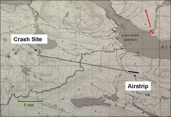
Around 0730, the fog started to clear and smoke was visible to the west of the airport on the side of a hill. At 0930, a Canadian Rangers team was dispatched to locate the aircraft. It took less than two hours to find the crash site. The wreckage was located about four nm west of the airfield, just north of the extended centreline for Runway 12 (see Figure 2).
The Airport
The Port Hope Simpson Airport is a certified aerodromeFootnote 2 operated by the Government of Newfoundland and Labrador. It is situated approximately two kilometres south of the village at 347 feet above sea level (asl). Runway 12/30 is 2500 feet long and 75 feet wide; it is gravel surfaced with one taxiway leading to the apron area. The runway has unidirectional flashing strobe lights, threshold and runway end lights, and medium-intensity runway edge lights with three variable settings. The airport has aircraft radio control of aerodrome lighting (ARCAL) Type K runway identification lighting.Footnote 3 The airport has two RNAV (GNSS)Footnote 4 approaches, one to Runway 12 and one to Runway 30. Both RNAV approaches indicate 3100 feet asl as the 25 nm minimum safe altitude (MSA). The minimum descent altitude (MDA) for the GPS approaches to Runways 12 and 30 are 721 feet and 541 feet agl, respectively (see Appendix A – RNAV (GNSS) Approaches Port Hope Simpson). There is no official weather reporting service at the airport. Aircraft are required to broadcast a traffic advisory on frequency 122.8 MHz within 5 nm of the airport when operating below 3300 feet asl. The airport is located in uncontrolled Class G airspace.
Weather
The weather in Forteau was clear with good visibility. The graphical area forecast for the southeast coast of Labrador at the time the pilot departed and for the duration of the flight was as follows: localised visibility of ¼ sm in fog, ceiling 100 feet agl, topped at 1000 feet agl, clear above and moderate mixed icing in clouds from the freezing level up to 12 000 feet asl. The freezing level was forecast to be approximately 5000 feet asl.
Mary's Harbour Airport, which is located on the Labrador coast approximately 22 nm southeast of Port Hope Simpson, is the closest aerodrome with weather reporting. The last terminal forecast (TAF) issued for Mary's Harbour available during the pilot's planning was no longer valid. The next TAF was issued around the aircraft's departure time and was likely not reviewed by the pilot. However, the hourly reports and special observations for Mary's Harbour were available and conditions were steadily improving (see Appendix B – Mary's Harbour Weather).
The pilot called a community contact in Port Hope Simpson at approximately 0545 to get an update on the weather. The fog was reported to be down over the trees, but was varying in height.
Port Hope Simpson is located in a river valley approximately 22 nm from the coast. The weather was described as approximately 200‑foot ceilings and reduced visibility of ¼ to ½ sm in fog; the wind was favouring Runway 12. Although weather services are not provided at the Port Hope Simpson Airport, the estimated weather was crosschecked by the investigation team with reference to geographic features visible from the airport and found to be quite accurate.
It is common on the east coast of Labrador to have localized fog patches that clear up quickly after the sun heats the surface. Fog is most prevalent in coastal areas, where moisture is abundant. The presence of fog can vary dramatically depending on local geographic features.
The Operator
Strait Air 2000 Ltd. is a charter operation based in Forteau with a remote base in Lourdes de Blanc-Sablon, Quebec. The company operated one de Havilland Canada DHC-2 Beaver, one Piper PA-31-350 Chieftain, one Beech King Air 90, and the Britten-Norman BN.2A‑27 Islander (Islander). The company conducts operations under subpart 702 and 703 of the Canadian Aviation Regulations (CARs). Forteau is a private airstrip and does not have any navigational approaches or weather services. Pilots obtain weather information by internet and telephone calls to persons in location at their various destinations. The company operated a self‑dispatch system for flight operations.Footnote 5 Flight following was conducted using a high‑frequency (HF) radio; all arrivals and departures were reported through the Strait Air dispatcher. When outside of telephone or HF radio coverage, air traffic services are utilised to relay messages to and from the company.
The Pilot
The pilot held a Commercial Pilot License – Aeroplane with a Group 1 instrument rating valid until December 2009. He had approximately 13 500 hours, most of which was accumulated on the east coast of Canada, flying single-engine floatplanes in VFR operations. The pilot had completed recurrent instrument flight rules (IFR) training on the Islander in November 2008 and had recently flown an IFR trip to Nunavut. He had over 600 hours on the Islander. The pilot flew 1.5 hours on 04 June 2009, 1.5 hours on June 05, and had a day off on June 06. The pilot was off-duty when not flying. Fatigue was not considered as a contributing factor in this accident. Records indicate that the pilot was certified and qualified for the flight in accordance with existing regulations.
The Aircraft
The Islander is a high-wing, twin‑engine aircraft with fixed, tricycle landing gear (see Photo 1). C‑FJJR was equipped and certified for instrument flight rules (IFR) operation. The aircraft was equipped with a global positioning system (GPS) that could be used to conduct the Port Hope Simpson GPS approach. However, the company was not approved to conduct GPS instrument approaches. Single-pilot IFR was not approved because the aircraft was not equipped with a functioning autopilot. The aircraft, equipped with standard fuel tanks and optional wing tip fuel tanks, departed Forteau with a full load of fuel (154 imperial gallons, approximately 5.5 hours of flight). Although the aircraft was equipped with anti- and de-icing systems, it was not approved for flight in icing conditions. The aircraft was equipped with a Pointer 4000-10 emergency locator transmitter (ELT), but there was no signal received after impact.

Records indicated that the aircraft was certified, equipped, and maintained in accordance with existing regulations and approved procedures. The aircraft had no known deficiencies before the accident flight. The weight and centre of gravity were within the prescribed limits at the time of the accident. There was sufficient fuel on board to complete the flight. The aircraft was not equipped with onboard recorders and these were not required by regulation (CAR 605.33).
Site Information
There was no evidence of tree strikes in the area of the crash site. The aircraft impacted the ground in a near-vertical attitude with no rotation about the longitudinal axis. The fuselage and wings were extensively damaged by impact forces and a post‑crash fire (see Photo 2). The fuselage was oriented in a northerly direction parallel to the hillside. The wreckage was located on the east side of a heavily wooded hill at approximately 490 feet asl.

There was no indication of pre-impact structural failure or failure of the flight control system. The damage noted on the propeller and spinner of both engines was consistent with rotation at the time of impact. There was no indication of a pre-existing condition that would have prevented the engines from performing normally.
Analysis
The sole occupant of the aircraft was fatally injured in the accident. There were no witnesses to the final moments of the flight and there were no onboard recording devices to assist investigators. The aircraft impacted the ground in a near-vertical attitude, suggesting an in-flight loss of control. As a result, this analysis focuses on possible scenarios for why the aircraft departed controlled flight and collided with terrain.
Although the aircraft was extensively damaged, there did not appear to be any evidence suggesting a problem with the flight controls or engines. Also ruled out was the scenario of pilot incapacitation. The application of power less than two seconds before impact indicates that the pilot was still trying to fly the aircraft. The investigation also ruled out turbulence as a factor for loss of control because there were no significant conditions in the area that could cause turbulence.
Visibility and ceilings were reported to be quite low in the Port Hope Simpson area. Therefore, the pilot would have been faced with the decision to return to Forteau and wait for the weather to improve, find a routing under the weather following lower terrain, or climb up into the weather to conduct an instrument approach.
The following scenarios were considered:
- If the pilot was attempting to return to Forteau, he was likely flying at a low altitude and a slower speed in order to maintain visual contact with the ground. The pilot may have inadvertently entered cloud and allowed his airspeed to decrease to the point of aerodynamic stall. Depending on the altitude of the aircraft at the point of stall, the pilot may not have been able to recover before the aircraft impacted the ground.
- If the pilot was trying to fly below and around the weather and suddenly lost contact with the ground or was faced with rapidly rising terrain, he would have had to abruptly initiate evasive action. If trying to maximise the climb with a steep nose-high attitude he may have inadvertently allowed the speed to decrease to the point of aerodynamic stall. Alternatively, he may have tried to turn away from rising terrain/weather and in doing so increased the aerodynamic wing loading and the angle of attack to the point of aerodynamic stall. Depending on the altitude of the aircraft at the point of stall, the pilot may not have been able to recover before the aircraft impacted the ground.
- The aircraft was equipped with a GPS; however, the company was not approved to conduct IFR approaches using the GPS. The company was certified for two-pilot IFR operations, but single-pilot IFR operations were not approved due to the lack of a functioning autopilot. The lack of a functioning autopilot imposes a high workload on a single pilot in IFR conditions (for example, tuning radios, programming navigation aids, reviewing approach plates, handling communications, and flying the aircraft). If the pilot decided to execute a GPS approach, it is possible that he inadvertently allowed the airspeed to decay towards the stalling speed while occupied with other flying-related tasks. Depending on the altitude of the aircraft at the point of stall, the pilot may not have been able to recover before the aircraft impacted the ground.
- The investigation also considered the possibility of icing in cloud while conducting an IFR approach as an initiating factor to a stall. It is unlikely that the pilot would climb any higher than the minimum safe altitude (MSA) while reverting from VFR low‑level flight to an IFR approach. The possibility of icing in cloud was eliminated as the freezing level was above the MSA for the approach. The instrument approach scenario is unlikely, given that the MDAs for both runways would have precluded a visual descent and landing.
None of these scenarios could be validated; however, an aerodynamic stall is a common factor.
The degree of aircraft destruction and the intensity of the post-crash fire likely precluded the operation of the ELT.
The following TSB laboratory report was completed:
- LP 079/2009 – Analysis of Exhaust Stub
This report is available from the Transportation Safety Board of Canada upon request.
Finding
Finding as to Causes and Contributing Factors
- The aircraft departed controlled flight, likely in an aerodynamic stall, and impacted terrain for undetermined reasons.
Other Finding
- The lack of onboard recording devices prevented the investigation from determining the reasons why the aircraft departed controlled flight.
This report concludes the Transportation Safety Board's investigation into this occurrence. Consequently, the Board authorized the release of this report on .
Appendices
Appendix A – RNAV (GNSS) Approaches Port Hope Simpson


Appendix B – Mary's Harbour Weather
METAR CYMH 070400Z AUTO 12004KT 2 1/8SM BKN000 03/03 A2988 RMK VSBY
VRBL 0.7V9.+ SLP120=
________________________________________
SPECI CYMH 070434Z AUTO 14004KT 1/8SM OVC000 03/03 A2987=
________________________________________
SPECI CYMH 070450Z AUTO 14004KT 1/2SM OVC000 03/03 A2987=
________________________________________
SPECI CYMH 070454Z AUTO 13003KT 1 1/8SM OVC000 03/03 A2987 RMK VSBY
VRBL 0.4V6.0=
________________________________________
SPECI CYMH 070458Z AUTO 13003KT 3SM OVC000 03/03 A2987=
________________________________________
METAR CYMH 070500Z AUTO 13004KT 4SM OVC000 03/03 A2987 RMK SLP116=
________________________________________
METAR CYMH 070600Z AUTO 10005KT 9SM OVC002 03/03 A2986 RMK SLP114=
________________________________________
SPECI CYMH 070618Z AUTO 10005KT 9SM OVC001 03/03 A2987=
________________________________________
SPECI CYMH 070651Z AUTO 12005KT 9SM OVC002 03/03 A2986=
________________________________________
METAR CYMH 070700Z AUTO 13004KT 9SM OVC002 03/03 A2986 RMK SLP112=
________________________________________
SPECI CYMH 070703Z AUTO 13004KT 9SM OVC001 03/03 A2986=
________________________________________
SPECI CYMH 070713Z AUTO 15002KT 9SM OVC002 03/03 A2986=
________________________________________
SPECI CYMH 070740Z AUTO 15002KT 9SM OVC001 03/03 A2985=
________________________________________
SPECI CYMH 070754Z AUTO 00000KT 9SM FEW001 BKN005 OVC098 03/03 A2985=
________________________________________
SPECI CYMH 070757Z AUTO 12002KT 9SM FEW001 OVC004 OVC098 03/03 A2985=
________________________________________
METAR CYMH 070800Z AUTO 00000KT 9SM FEW001 OVC004 OVC098 03/03 A2985
RMK SLP108=
________________________________________
SPECI CYMH 070822Z AUTO 00000KT 9SM BKN006 OVC098 04/03 A2985=
______________________________________
SPECI CYMH 070827Z AUTO 09003KT 9SM SCT006 OVC098 04/03 A2985=
________________________________________
*METAR CYMH 070900Z AUTO 11005KT 9SM SCT098 04/03 A2986 RMK SLP112=
Aviation Routine Weather Report, issued for Mary's Harbour on the 7th day at 0900 Zulu (Coordinated Universal Time) – 0630 NDT from an automatic reporting station: wind 110° True at 5 knots, visibility 9 statute miles, scattered cloud at 9800 feet agl, temperature 4°C , dew point 3°C , altimeter setting 29.86 inches of mercury, remarks sea level pressure 1011.2 hectopascals
________________________________________
METAR CYMH 071000Z AUTO 14008KT 9SM CLR 05/02 A2985 RMK SLP110=SPCN48 CWAO 070434
* Closest to the time of the accident