Aviation Investigation Report A09Q0190
Collision with Cable
Robinson R44 II Raven (Helicopter) C-GJMP
Franquelin, Quebec
The Transportation Safety Board of Canada (TSB) investigated this occurrence for the purpose of advancing transportation safety. It is not the function of the Board to assign fault or determine civil or criminal liability. This report is not created for use in the context of legal, disciplinary or other proceedings. See Ownership and use of content.
-
Table of contents
Summary
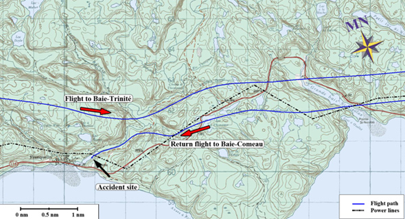
The privately owned and operated Robinson R44 II Raven helicopter (registration C-GJMP, serial number 12511), took off for a visual flight rules flight from a work site at Baie-Trinité, to Baie-Comeau, Quebec. At 1249 Eastern Standard Time, the helicopter struck a ground wire atop a power line crossing the Franquelin River and crashed on the river bank below. The pilot sustained fatal injuries and the 2 passengers on board were seriously injured. A pedestrian discovered the wreckage at approximately 1410 and advised the authorities.
Other Factual Information
History of the flight
The aircraft was owned and operated by the pilot. On the morning of 12 November 2009, the pilot departed Québec/Jean Lesage International Airport, Quebec, at 0613 Footnote 1 on a visual flight rules (VFR) flight to Baie-Comeau Airport (CYBC). After refuelling at CYBC, the pilot departed VFR for a work site at Baie-Trinité, and returned to the city of Baie-Comeau to land in an open area situated behind his business location. Both flights were uneventful. No technical issues arose during these 2 flights.
At approximately 1140, 3 employees boarded the helicopter: one employee who was to be transported to the Baie-Trinité work site, and 2 others who were to remain on board for the return flight to Baie-Comeau. The employee was dropped off at the work site and the helicopter took off from Baie-Trinité at 1227.
Weather was favourable for VFR flight and the sky was clear. Winds were blowing from the west-southwest at 16 knots and gusting to 21 knots, giving light turbulence at low altitude over the hilly terrain. Weather was not considered a contributing factor in this occurrence.
After taking off from Baie-Trinité, the helicopter was flown south towards the St. Lawrence River, then west past the Pointe-des-Monts lighthouse and the town of Godbout, Quebec, towards Baie-Comeau (See Appendix A – Occurrence Flight Path). When the helicopter reached the Franquelin River Footnote 2, 10 nautical miles (nm) east-northeast of the city of Baie-Comeau, the flight continued through the river valley towards the St. Lawrence River in a west-southwesterly direction, initially at approximately 426 feet above sea level (asl) then descending to 255 feet asl. Footnote 3
The pilot became aware of the power line immediately prior to colliding with it and attempted evasive action. The aircraft struck the first of 2 lightening protection ground wires strung atop the power line that spans the river, causing it to break. At 1249, the global positioning system (GPS) data shows a noticeable increase in altitude from 255 feet to 285 feet asl and a marked decrease in speed from 69 to 34 knots. The aircraft then climbed slightly, flying over the second ground wire and descended towards the river below, coming to rest on its right side, on a sand bank located approximately 200 feet further down the river along its flight path. The tide was ebbing; only the lower parts of the helicopter were submerged in water. The wire strike caused a local power outage, which was also recorded at 1249.
A pedestrian passing by discovered the wreckage at approximately 1410, sought out assistance and waited with the injured until help arrived. Due to the local electricity power outage, a Hydro-Québec helicopter pilot and a work crew, working in the vicinity, were dispatched to the area to search out the cause. They discovered the broken ground wire and the wreckage site at 1440. Local authorities and first responders arrived nearby and the Hydro-Québec helicopter pilot assisted in transporting them to the site and in evacuating the 2 injured passengers and the pilot. The evacuation was completed by approximately 1610.
No emergency radio calls were made by the pilot on any of the frequencies known to be used in the area to signal any technical difficulties associated to the helicopter prior to the occurrence.
Wreckage and Impact Information
The helicopter was substantially damaged on impact with the sand bank. It struck the ground in a slight nose-down, right-side-low attitude. The landing gear skids were heavily damaged and broke by overload impact forces with the ground. The emergency locator transmitter (ELT) antenna cable was severed.
Collision with the ground wire was evident at the left bottom of the mast fairing area just below the pitot tube. No wire markings were evident on the right side of the mast fairing. The collective and cyclic control tubes running vertically alongside the rotor mast were bent and showed marks from impact with the wire (see Photo 1). The bending of the control tubes rendered the collective and cyclic controls partially inoperable, likely allowing the pilot limited control of the helicopter during the descent towards the river.

There were no other cable markings observed on the rotor blades, tail rotor, tailboom or skids. Flight controls failed in overload on impact with the ground. The tail rotor drive shaft that connects the transmission to the tail rotor failed in overload on impact and showed signs of rotation; this confirms the engine was producing power. The transmission freewheeling unit Telatemp Footnote 4 strip showed no signs of discoloration, therefore eliminating the possibility of a freewheeling unit malfunction prior to the occurrence. Seat belts and shoulder harnesses were used by all occupants. Both passengers remained secured to their seats. Seat structures were heavily damaged. The pilot was found on the ground outside the right side of the helicopter.
Pilot
Records indicate that the pilot was certified and qualified for the flight in accordance with existing regulations. He obtained his private pilot airplane license in February 1988 and had a total of approximately 500 hours on fixed-wing aircraft. He obtained his private pilot helicopter license in June 2009 and had accumulated approximately 237 hours on helicopters. The majority of these hours were completed on Robinson R44 type helicopters with the exception of 15 hours on R22 helicopters during initial training.
The pilot's category 3 aviation medical certificate was valid at the time of the occurrence. The pilot had flown the route between Baie-Comeau and Baie-Trinité on many occasions prior to the occurrence. Nothing was found which would indicate that the pilot's performance was degraded by physiological factors or fatigue.
Aircraft
The Robinson R44 II Raven is a single-piston engine helicopter capable of carrying 1 pilot and 3 passengers. The private helicopter was registered under a company name belonging to the pilot; he became owner of the aircraft in September 2008, purchasing it new. Technical records indicated that the helicopter was certified, equipped and maintained in accordance with the existing regulations. The helicopter had accumulated a total of 222 hours since its manufacture in 2008. Forty-three hours of service were recorded since its last annual 100-hour inspection. The weight and balance, and the centre of gravity were within limits at the time of the occurrence.
The helicopter was not equipped with a cockpit voice recorder or a flight data recorder; neither is required by regulation.
The aircraft was equipped with a portable GPS Garmin GPSMAP®496 Footnote 5. Its data was successfully downloaded.
The display on this model of GPS is capable of:
- highlighting in yellow, terrain when the aircraft is between 1000 feet and 100 feet above ground level (agl);
- highlighting in red, terrain when the aircraft is within 100 feet agl; and
- displaying unlighted obstacles below 1000 feet.
The display can be accompanied by an aural warning. These features are available for flights over the United States. However, while some areas located close to the United States border may receive coverage, the manufacturer cannot assure coverage in Canada.
It was determined that, although terrain features were available in the occurrence area, obstacle warning coverage was not. Footnote 6 It could not be determined what features were activated on the GPS unit and if the pilot was aware of those features and associated limitations when used in Canada.
The power line is displayed on the aviation VFR navigation chart that was found in the helicopter Footnote 7. But the route taken was familiar and the pilot may not have been attentive to the GPS display or the navigation chart.
Cable Markings
Power Line 1615 crosses the Franquelin River (see Photo 2). There are no markers on the wires crossing the river nor are they required by regulation. The pylons supporting the wires are 107 and 77 feet agl and are situated on each side of the river bank. The lowest height at which the top ground wires hang is 283 feet above the river when the water is at low tide. The main transmission lines hang 36 feet below the ground wires; 247 feet above the river.

Canadian Aviation Regulations (CAR) 601.19 states that where it is likely that a building, structure or object is hazardous to aviation safety because of its height and location, the Minister may order that it be marked and lighted in accordance with the standards specified in the Standards Obstruction Markings Manual. Footnote 8 Obstruction marking is otherwise voluntary. When an obstacle is marked and/or lighted, the manual specifies as follows Footnote 9 ;
Any obstruction greater than 90m (300 feet) agl within 2 nautical miles of the imaginary centre line of a recognized VFR route such as, but not limited to, a valley, a railroad, a transmission line, a pipeline, a river or a highway;
Any permanent catenary wire crossing where any portion of the wires or supporting structures exceed 90m (300 feet) agl.
Because of the chosen route and the way the power line zigzags across the landscape, the pilot crossed the line 3 times on the return trip to Baie-Comeau. The helicopter would have crossed the power line a fourth time at the Franquelin river location on the edge of the St. Lawrence River. Franquelin is situated on the direct VFR route between Baie-Comeau and Sept-Îles, Quebec.
Environment and Low Flying
Several provisions within the Canadian Aviation Regulations (CARs) apply to low altitude flying. Since the flight took place over a non-built-up area, the following provision is the one most relevant to this occurrence;
Except where conducting a take-off, approach or landing or where permitted under section 602.15, no person shall operate an aircraft at a distance less than 500 feet from any person, vessel, vehicle or structure. Footnote 10
The Transport Canada Aeronautical Information Manual (AIM), TP 14371E, a reference often studied and used by pilots, states that pilots should use caution when operating at low level because power lines, especially the ground wires hanging above the main conductor wires, are more difficult to see even in good visibility (see Figure 1) Footnote 11. Pilots are taught to look for the presence of towers or poles to detect the presence of wires or cables. They are also taught to fly over the towers, the highest points along the line. Unmarked wires are more difficult to detect.

The limitations of the human eye render detection of wires or cables difficult if they do not contrast well against the background. The grey coloured ground wire would not have contrasted well against the grey colour of the waters of the St. Lawrence River. If a pilot chooses to fly at low altitude and does not scan the surrounding area adequately, it is possible that certain obstacles in his periphery, such as the towers atop the cliffs on each side of the river, may go undetected.
The helicopter was flying in a west-southwesterly direction over the river. The sun's height above the horizon was approximately 20 degrees at the time and location of the occurrence. Its position was from the south-southwest at 203 degrees. Therefore, the pilot would have been flying towards the sun and with it slightly on the left side of the aircraft while flying over the river. Flying into the sun will cause glare on the windscreen and will obscure visibility outside the aircraft when looking forward.
Emergency Locator Transmitter
ELTs were originally intended for use on the 121.5 MHz frequency to alert air traffic control and aircraft monitoring the frequency. In 1982 COSPAS SARSAT Footnote 12, a satellite-based monitoring system was implemented to provide a better receiving source for these signals. As of 01 February 2009, the international satellite system discontinued satellite-based monitoring of the 121.5/243-MHz frequencies; the satellite system now monitors the 406 MHz frequency only. It was recommended that aircraft operators change their 121.5 MHz ELT to the new digital 406 MHz ELT which also allows search and rescue personnel to have information specific to the owner and the aircraft. Footnote 13 The 406 MHz ELT is relatively new to the aviation industry.
The ELT Footnote 14 found on this helicopter was manufactured by KANNAD and installed by Robinson Helicopters prior to sale. The ELT was capable of transmitting digital data on frequency 406 MHz and audio data on frequency 121.5 MHz. This ELT unit can be programmed with aircraft specific information in 2 ways: for units without a programmable dongle, the information is entered directly into the ELT unit; for units with a programmable dongleFootnote 15, the aircraft specific information must be programmed into the dongle. When a pre-programmed dongle is plugged into the ELT and the function switch is cycled from the OFF to the ARM position the dongle will then download its data into the ELT. The ELT installation on the occurrence aircraft included; the ELT unit, a programmable dongle and a Remote Control Panel (RCP).
On acquiring the helicopter, the owner requested the aircraft maintainer to program the ELT and had ensured that the ELT was registered as required. The aircraft maintainer, however, was unaware that the aircraft was equipped with a programmable dongle and did not program it when the ELT unit was initially programmed with the owner and aircraft information. The occurrence helicopter's ELT unit was tested serviceable in January 2009 when it was tested without its programmable dongle. Footnote 16
TSB testing of the ELT revealed that, although the antenna cable was severed, the unit was serviceable and had activated on impact. Due to the severed antenna cable, both the 406 and 121.5 MHz signals were significantly attenuated. The COSPAS-SARSAT Mission Control Centre (CMCC) confirmed that no 406 MHz signal had been received in and around the time of the occurrence. The Hydro-Québec helicopter did receive the 121.5 MHz audio signal but only in close proximity to the crash site.
In addition, the severed antenna cable caused overloading of the last output amplification stage of the 406 MHz transmitter. This eventually caused the failure of the Q8 amplifier resulting in an additional attenuation of the 406 MHz signal. Activation of this type of ELT, even for test purposes, without a proper load such as an antenna, can result in damage to its circuitry, rendering the device unserviceable.
It was also determined that the occurrence ELT was transmitting on the Test User Protocol, a country code of 227 (France) and an ID code of S1386932 instead of transmitting in the ‘Normal' mode, country code of 316 (Canada) and the correct ID code of C05D84. It was found that the dongle had not been programmed to reflect the current owner's information. By default a dongle which has not been re-programmed with this information restores the ELT to that which was programmed in the dongle when the ELT was initially installed in the aircraft before it left the manufacturer: that is a Test User Protocol with country code 227 (France) and ID code SI386932.
The investigation also revealed that while ELT programmable dongles are optional , unlike other optional equipment, they do not appear in the aircraft equipment list.

The ELT Unit, when installed in the aircraft, is equipped with a self-test function which permits an owner or maintainer to determine whether it is functioning properly and capable of transmitting aircraft specific information. No self-test or transmission test had been performed since acquiring the aircraft in 2008. Had a self-test been done by either the pilot or maintenance, the visual and audible indicators would have displayed the programming fault. KANNAD recommends a self-test and a transmission test on first power up of the ELT installationFootnote 17. KANNAD recommends a self-test once a month. Transport Canada recommends following the manufacturer's instructions.
After the ELT unit was tested in January of 2009 it was placed back in the aircraft, connected to the dongle and the function switch was placed from the OFF to the ARM position, the ELT was reprogrammed with the out of factory dongle information (i.e. Test User Protocol). Had the dongle been programmed with the proper identification information, the ELT would have been configured to transmit the correct information. Had a self-test been performed at this point, the faulty programming would have been detected.
There are provisions for test coding beacons for demonstrations, type approval, national tests, training exercises and research purposes. Therefore, any transmission received by the COSPAS-SARSAT CMCC in the Test User Protocol mode may not be treated in the same manner as one in the Normal mode.
Dongle installations are fairly common and other ELT manufacturers offer the option of purchasing programmable dongles. One way of differentiating between a standard dongle installation and a programmable dongle installation is the presence of 2- or 3-wire plastic quick disconnect connectors installed to facilitate removal.
Once an ELT is installed in an aircraft, it is important to conduct, as per the Installation and Operations Manual, a self-test to validate the integrity of the installation and programming. In the absence of correct ELT information, accurate direction to responders to the location, aircraft and owner, could be delayed.
The following TSB Laboratory reports were completed:
- LP 155/2009 –GPS Analysis
- LP 156/2009 – ELT Examination
- LP 171/2009 – Flight Dynamic Analysis
Analysis
Low flying increases the risk of collision with wires or other obstacles. The direction of flight into the sun would have caused glare on the windscreen and would have most likely decreased the pilot's forward visibility and ability to see the wires. Also, the wires were unmarked, rendering them more difficult to detect. A thorough scan for obstacles in front and in periphery of the aircraft might have helped to detect the towers of Line 1615 situated atop the cliffs on either side of the river. Although the pilot saw the wires immediately prior to colliding with them and attempted evasive action, a collision with the first of the 2 ground wires ensued.
While the aircraft was equipped with a GPS capable of providing the pilot with obstacle and terrain warnings when flying at low altitude, only the terrain display feature was functional in the area the flight took place. In addition, it could not be determined if the pilot was aware of those features and associated limitations when used in Canada. The GPS is an aid to navigation and should not replace the use of authorized navigation charts.
Cables and wires may be unmarked if they are not considered to be an aeronautical or marine hazard. The towers atop the cliffs on either side of the river and the ground wire lines and main power lines were not deemed a hazard. While the location where Line 1615 crosses the Franquelin River is not close to an aerodrome, it is situated on the VFR GPS route from Baie-Comeau to Sept-Îles. Without careful flight planning, flights conducted at low level are at increased risk of collision with unmarked hazards such as wires or other obstacles.
The 406 MHz ELTs are relatively new to the aviation industry. The helicopter's ELT installation included a programmable dongle, information which did not appear on the aircraft equipment list. The owner completed the required registering of the ELT unit but had not done a periodic self-test as recommended by the ELT manufacturer. The maintenance facility had confirmed the ELT unit tested serviceable but did not know the dongle was programmable and therefore had not programmed it or had it programmed to match the owner and aircraft information. No self-test or transmission test had been completed since the owner acquiring the aircraft. The fact that the programmed dongle information supersedes the ELT programmed information was not widely known. The ELT manufacturer recommends a self-test once a month to verify the integrity of the installation however there are no regulatory requirements to conduct this self-test. A signal received by the COSPAS-SARSAT CMCC in the Test mode would not necessarily initiate search and rescue in the same manner than that of a signal received in the Normal mode.
The 406 and 121.5 MHz signals were significantly attenuated due to the severed antenna cable. The failure of the Q8 amplifier resulted in an additional attenuation of the 406 MHz signal. Activation of this type of ELT, even for test purposes, without a proper load such as an antenna, can result in damage to its circuitry, rendering the device unserviceable.
An improperly-programmed dongle may result in the transmission of incorrect information thereby delaying search and rescue.
Findings
Findings as to causes and contributing factors
- The helicopter was flown at low altitude, increasing its exposure to a collision with obstacles.
- The sun's glare likely degraded the pilot's ability to detect the unmarked power lines and ground wires in time to avoid a collision.
- The helicopter struck the ground wire likely rendering the helicopter partially uncontrollable and it crashed in the river below.
- Given the difficulty in seeing unmarked wires, pilots must plan their flight path appropriately before operating at low levels, especially in valleys.
- A dongle that has not been properly programmed may result in the transmission of incorrect information, thereby delaying search and rescue. An emergency locator transmitter (ELT) self-test would confirm a programming fault.
- The ELT antenna cable became severed during the impact sequence, increasing the risk of the signal not being detected.
Other findings
- Turning an ELT ON or conducting a self-test without installing a load (antenna) may overload the transmission amplifier rendering the unit unserviceable.
- The global positioning system (GPS) terrain display feature was operational in the area the flight took place, however the obstacle warning feature was not. The GPS is an aid to navigation and should not replace the use of authorized navigation charts.
Safety Action Taken
On 12 July 2010, the TSB sent, Aviation Safety Information Letter A09Q0190-D1-L1, Awareness – 406 MHz ELT Inappropriate Transmission Mode due to Programmable Dongle Information, to Transport Canada. This letter highlighted the importance of informing aircraft operators, owners, maintainers and avionics facilities of the purpose of the programmable dongle.
Transport Canada has prepared an article regarding the emergency locator transmitter (ELT) Programmable Dongle, which will be published in the 3/2011 issue of the Aviation Safety Letter.
The ELT Manufacturer (KANNAD) have developed a new family of ELTs which have an additional internal antenna and a global positioning system.
This report concludes the Transportation Safety Board's investigation into this occurrence. Consequently, the Board authorized the release of this report on .
Appendices
Appendix A – Occurrence Flight Path