Loss of control and collision with terrain
Privately registered
Piper PA-32-260, N50DK
Kingston Airport, Ontario, 3.5 NM N
The Transportation Safety Board of Canada (TSB) investigated this occurrence for the purpose of advancing transportation safety. It is not the function of the Board to assign fault or determine civil or criminal liability. This report is not created for use in the context of legal, disciplinary or other proceedings. See Ownership and use of content. Masculine pronouns and position titles may be used to signify all genders to comply with the Canadian Transportation Accident Investigation and Safety Board Act (S.C. 1989, c. 3).
Summary
On 27 November 2019, at 1601 Eastern Standard Time, a privately registered Piper PA-32-260 aircraft (United States registration N50DK, serial number 32-29) departed Toronto/Buttonville Municipal Airport, Ontario, destined for Québec/Neuville Airport, Quebec. The pilot and 6 passengers were on board. The aircraft was operating under visual flight rules and departed during daylight hours. However, the majority of the planned flight was to take place during the hours of darkness, as official night began an hour after departure. During the flight, in response to deteriorating weather, the pilot made a number of altitude and track deviations. As the aircraft neared Kingston Airport, Ontario, the pilot made radio contact with NAV CANADA’s Kingston flight service station, stating his intention to land there. At 1705, the aircraft struck terrain approximately 3.5 nautical miles north of Kingston Airport. All 7 occupants were fatally injured. The aircraft was destroyed. There was no post-impact fire.
1.0 Factual information
1.1 History of the flight
On 27 November 2019, at approximately 1530,Footnote 1 the pilot and 6 passengers arrived at Toronto/Buttonville Municipal Airport (CYKZ), Ontario, where the pilot’s private aircraft, a Piper PA-32-260 (United States [U.S.] registration N50DK, serial number 32-29) was parked. Their intention was to conduct a visual flight rules (VFR) flight to Québec/Neuville Airport (CNV9), Quebec, which is 9 nautical miles (NM) west-southwest of Québec/Jean Lesage International Airport (CYQB), Quebec. Using the planned direct route, the 372 NM flight was to take approximately 3 hours.
At 1601, the aircraft departed from Runway 15 at CYKZ with the pilot and the 6 passengers on board. Although the departure took place during daylight hours, the majority of the planned flight, including the landing, was to be conducted at night.
The aircraft proceeded in the general direction of CNV9 for approximately 33 minutes (Figure 1). It climbed initially to the planned altitude of 3500 feet above sea level (ASL), where it flew for 15 minutes, before descending to 2000 feet ASL.
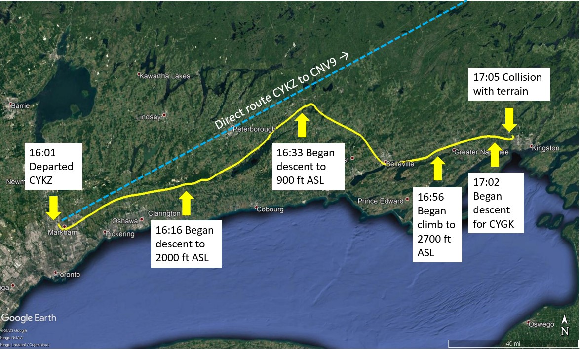
At 1633, the aircraft began a further descent and, at 1635, made a significant deviation toward the southeast, descending to as low as 900 feet ASL (200 feet above ground level [AGL]) near Havelock, Ontario. As the aircraft continued in a southeast direction toward Belleville, Ontario, the altitude varied between 1000 and 2800 feet ASL. Southwest of Belleville, at 1646, the aircraft turned toward the northeast at 2500 feet ASL.
At about 1656, the aircraft climbed to 2700 feet ASL and flew eastward, and then began descending at 1701:45. At this time, the aircraft was approximately 6 NM west of Kingston Airport (CYGK), Ontario.
At 1702:55, the pilot made his 1st radio call to the CYGK flight service station (FSS) indicating that he was 4 NM north, inbound for a straight-in approach on Runway 19. At this time, the aircraft was actually 4.5 NM to the west, tracking 102° magnetic (M), in a steady descent through 2400 feet ASL at approximately 760 fpm (Figure 2).

At 1703:10, the CYGK FSS flight service specialist asked the pilot to confirm his position. The pilot replied that he was 4 NM to the north. The aircraft was actually 3.5 NM to the west, still tracking 102°M, in a steady descent through 2200 feet ASL. At the end of his transmission, the pilot began a sentence indicating that he would just overfly the field, but he hesitated and did not complete the sentence.
At 1703:46, the specialist informed the pilot that he had made his initial contact too late, and that initial contact should be made 10 to 15 NM away from the airport. The specialist then requested the original point of departure of the flight.
During this transmission, the pilot began a gradual left turn (away from the airport), while maintaining a steady rate of descent through 1400 feet ASL, and slowed to about 90 to 95 knots.Footnote 2
As the aircraft continued the left turn at up to a 40° bank angle, it continued descent at a rate approaching 2000 fpm.
At 1704:01, the specialist asked the pilot for the aircraft type and to confirm his intention to land on Runway 19; the pilot replied to both questions, stating his aircraft type and confirming his intention to land on Runway 19.
At 1704:24, the specialist informed the pilot of the current wind and altimeter setting. He also informed the pilot that he did not have the aircraft on radar, and requested the aircraft’s current position.
At 1704:38, in a delayed response that would be his final radio transmission, the pilot replied that he was 2.5 NM to the north, which was the actual position of the aircraft as it continued its turn to the left, away from the airport. The specialist responded by indicating that the runway lights were on and asking whether the pilot had the runway in sight.
By 1704:45 the aircraft had descended to about 650 feet ASL (roughly 370 feet AGL) and the airspeed had increased to about 130 knots. At this point, the aircraft pulled up into a steep climb.
During the pull-up, which produced a vertical acceleration of about 1.7g, the left bank began to reduce. At 1704:55, while the climb rate was peaking at almost 4000 fpm, the aircraft rolled through wings level and continued rolling to the right in one continuous motion. The airspeed dropped by as much as 7 knots per second in the steep climb.
By 1704:59, the airspeed was approaching 60 knots. At this point, based on estimates derived from the data contained in a GPS (global positioning system) retrieved at the accident site, the angle of attack and lift coefficient increased rapidly, the pitch angle dropped, and the right roll increased rapidly.Footnote 3 The specialist attempted to contact the pilot. The aircraft was on the extended centreline of the approach for Runway 19, heading away from the airport.
At 1705:02, the aircraft’s altitude reached a peak of just over 1400 feet ASL before the final descent began. The final data points suggest that the airspeed fell to about 30 knots, the descent rate reached 2500 fpm, and the aircraft rolled right and inverted into a steep nose-down attitude.
The specialist made numerous attempts to contact the aircraft following their last transmission, but there were no further radio broadcasts from the aircraft.
A 406 MHz emergency locator transmitter (ELT) signal was received by the Canadian Mission Control Centre in Trenton, Ontario. Two aircraft were dispatched and began an aerial search, while some Kingston Police officers were dispatched to perform a ground search.
At approximately 1940, the aircraft was located in a wooded area 3.5 NM to the north of CYGK. All 7 occupants were fatally injured. The aircraft was destroyed and there was no post-impact fire.
1.2 Injuries to persons
| Degree of injury | Crew | Passengers | Persons not on board the aircraft | Total by injury |
|---|---|---|---|---|
| Fatal | 1 | 6 | 0 | 7 |
| Serious | 0 | 0 | 0 | 0 |
| Minor | 0 | 0 | 0 | 0 |
| Total injured | 1 | 6 | 0 | 7 |
1.3 Damage to aircraft
The aircraft was destroyed.
1.4 Other damage
Not applicable.
1.5 Personnel information
The pilot held a valid private pilot certificate issued by the Federal Aviation Administration (FAA) in the U.S. He did not hold a Canadian aviation document, nor was he required to by regulations. He was operating a U.S.-registered aircraft in Canada on the basis of his FAA certificate and was certified in accordance with existing regulations in the U.S.
The pilot began flight training in April 2017 and obtained his U.S. private pilot certificate in May 2018. He had accumulated 281 total flight hours before the occurrence flight, including 190.2 hours on the occurrence aircraft since purchasing it in February 2019.
According to his personal logbook, he had accumulated 29.7 hours of night flight time, of which 20.7 hours were in the occurrence aircraft. In the 6 months before the occurrence, the pilot had logged 10.6 hours of night flight, including 10 night takeoffs and 12 night landings.
The occurrence pilot logged 5.7 total simulated instrument hours and 3.2 actual instrument hours. One of the hours of simulated instrument time and the entire 3.2 hours of actual instrument time were logged on the occurrence aircraft.
Nearly all of the pilot’s flying experience had taken place in his home state of Texas; he had not flown in Canadian airspace before arriving in Toronto a few days before the occurrence.
1.6 Aircraft information
Records indicate that the aircraft was certified, equipped, and maintained in accordance with existing regulations and approved procedures. Nothing indicates that there was any airframe failure or system malfunction before or during the occurrence flight.
The aircraft was manufactured in 1965 by Piper Aircraft Corporation and had accumulated 5521.7 total flying hours prior to the occurrence flight. The engine had received a major overhaul in 2018. Records indicate that the most recent annual inspection was completed on 21 October 2019 and the aircraft had accumulated 39.7 hours since. The FAA type certificate data sheet indicates that the PA-32-260 is certified for both 6- and 7-place configurations. The occurrence aircraft was configured with 6 seats.
According to the Piper Cherokee Six Owner’s Handbook,Footnote 4 the stall speed of the aircraft with flaps up is 70 mph.
| Manufacturer | Piper Aircraft Corporation |
|---|---|
| Type, model and registration | PA-32-260, N50DK |
| Year of manufacture | 1965 |
| Serial number | 32-29 |
| Certificate of airworthiness/flight permit issue date | 06 June 1972 |
| Total airframe time | 5521.7 |
| Engine type (number of engines) | Lycoming, O-540-E4B5 (1) |
| Propeller/Rotor type (number of propellers) | Hartzell, HC-C2YK-1BF (1) |
| Maximum permissible take-off weight | 3400 lb |
| Recommended fuel type(s) | 100/130 minimum |
| Fuel type used | 100LL |
1.6.1 Weight and balance
The maximum take-off weight for the occurrence aircraft was 3400 pounds. The most recent weight and balance report for the occurrence aircraft was dated June 2010. This report stated the empty weight as 1929.25 pounds, leaving a useful load of 1470.75 pounds (for passengers, fuel, and baggage).
The pilot reportedly used 1500 pounds as his guideline for estimating how much load he could carry on the aircraft, and mentally added the weight of fuel and the estimated weights for the passengers and baggage to ensure that he remained under the maximum weight for the aircraft.
It was reported that the aircraft’s fuel tanks were filled before departure, which means the aircraft had a total of 84 U.S. gallons of fuel, weighing approximately 504 pounds. The actual weight of the 7 occupants was 1030 pounds, and the baggage recovered at the accident site weighed 135 pounds.
The investigation did not locate any documentation indicating the weight and balance calculation for the occurrence flight; however, weight and balance calculations completed by the TSB after the occurrence indicate that, at the time of takeoff, the aircraft was approximately 200 pounds over the maximum permissible take-off weight.
Based on fuel consumption estimates, the aircraft was approximately 100 pounds overweight at the time of the occurrence.
The investigation was unable to determine where each passenger had been seated in the rear of the aircraft, which precludes an accurate determination of whether the centre of gravity was within limits during the occurrence flight. However, calculations of various passenger and baggage configurations show that the centre of gravity likely would have been within the fore and aft limits had the weight been below the maximum take-off weight.
Flight characteristics for operation above the maximum weight of an aircraft are not documented in the aircraft performance section of the Pilot Operating Handbook, and cannot be accurately predicted by the pilot using available information. Increased take-off distance, increased stall speed, reduced rates of climb, and reduced control response can result when flying an aircraft above its maximum weight.
1.7 Meteorological information
1.7.1 Weather information checked and available during flight planning
On 25 November 2019 (2 days before the occurrence flight), the pilot began to plan the occurrence flight using the ForeFlight Mobile application installed on his tablet (see section 1.8.1), entering a direct route between CYKZ and a few airports in the area around the city of Québec. On 26 November, the pilot entered a direct route between CYKZ and CNV9, with a few different proposed altitudes, one as high as 13 500 feet.
At 0830 on the morning of the occurrence flight (27 November 2019), a proposed departure time of 0830 the next morning (28 November 2019) was selected. Nearly an hour later, at 0925, after having reviewed numerous weather charts, the proposed departure time was adjusted to 1530 the same day. It was later reported that the pilot made the decision to leave on the occurrence day due to snow in the forecast for the next day.
The graphical weather products viewed on the pilot’s ForeFlight accountFootnote 5 were depictions of a scale that covered the entire continental U.S. The weather shown on these charts did, however, depict weather over the intended area of the occurrence flight, which closely adjoined the Canada–U.S. border.
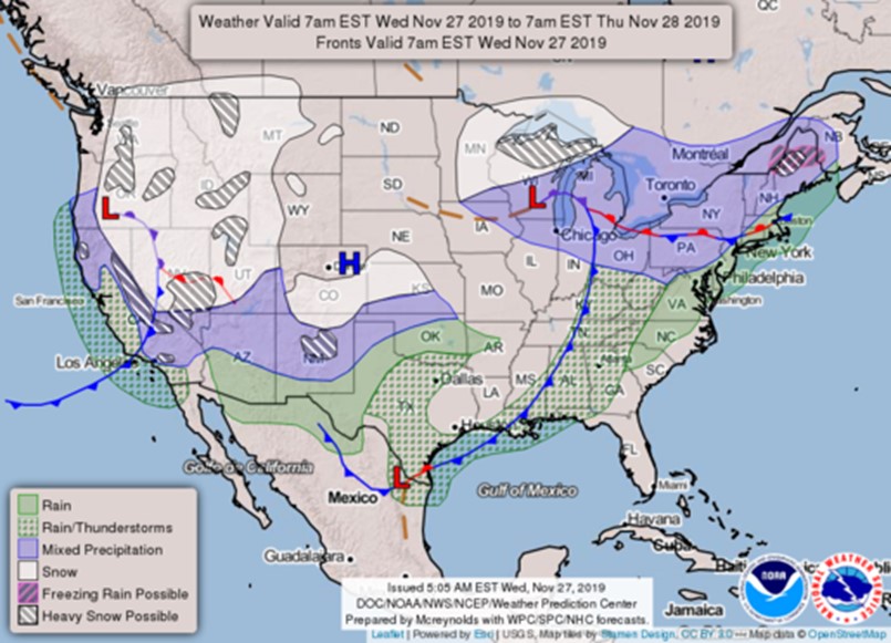
The 1300 surface analysis chart was accessed at 1529, 32 minutes before departure. It showed a large area of low pressure centred on the Great Lakes and moving toward the proposed route of flight. This type of weather system is typically associated with precipitation, reduced visibility, and low ceilings.
The low-pressure system depicted on the surface analysis was consistent with a chart the pilot viewed that morning entitled “Today’s Forecast,” produced by the U.S. National Oceanic and Atmospheric Administration (NOAA) and the U.S. National Weather Service (Figure 3). The NOAA chart clearly depicts a wide area of mixed precipitation (rain and snow) over the entire route of the planned flight.
Other aviation weather products, such as aerodrome routine meteorological reports (METARs) and aerodrome forecasts (TAFs), were available using ForeFlight when the pilot viewed the departure and arrival airport information on the morning of 27 November 2019.
CYKZ and CNV9 do not issue METARs and TAFs. The airport nearest to the arrival airport (CNV9) that issues a TAF is CYQB, which is 9 NM east-northeast of CNV9. For the expected arrival time of approximately 1900, the forecast was for winds from 070° true (T) at 20 knots, gusting to 30 knots, 1 statute mile (SM) visibility in light snow, and an overcast ceiling at 600 feet AGL. There was also a 30% probability of ¼ SM visibility, heavy snow, blowing snow, and an obscured ceiling at 400 feet AGL.
TAFs for the airports along the route of flight indicated that there would be strong, gusty winds, and periods of reduced visibility and rain at each of these airports, during the period of time that the aircraft would be overflying them.
The TAF for Ottawa/Macdonald-Cartier International Airport (CYOW), Ontario, indicated that for the time that the flight would be passing overhead CYOW, which was 1.5 hours after departure on the proposed route of flight, the visibility was expected to drop as low as 2 SM, and the ceiling to be as low as 600 feet AGL.
At the time of departure from CYKZ, the METAR at CYOW indicated visibility of 3 SM due to light rain and mist, with a temperature of 3 °C, and a dew point of 2 °C.
According to the planned direct route, after approximately 2 hours en route, the aircraft would be flying approximately 30 NM north of Montréal/Pierre Elliott Trudeau International Airport (CYUL), Quebec. The CYUL TAF for this time period forecasted a visibility of 2 SM and an overcast ceiling at 600 feet AGL.
On the morning of the occurrence, 4 airport pages were accessed on the pilot’s ForeFlight application: Toronto/Lester B. Pearson International Airport (CYYZ), CYKZ (departure airport), CYQB, and CNV9 (arrival airport). However, the investigation was not able to determine whether the pilot reviewed the METARs and TAFs for CYYZ or CYQB before the occurrence flight using the ForeFlight Mobile application or from another source of weather information.
Prior to departure, the pilot had asked around inside the terminal building at CYKZ and obtained assistance to access weather information for his planned route that day. The pilot had reportedly shown a weather forecast map to an acquaintance and had pointed out an area of precipitation near the destination, but the pilot had said that it would not be a problem because it was not a very large area, and he could simply fly around it.
1.7.2 Weather encountered en route
At the time of departure, there were 2 significant areas of precipitation depicted on Environment and Climate Change Canada radar between CYKZ and CYOW, approximately halfway to the planned destination along the flight-planned route. The 1st area, a narrow band of precipitation in a line from the northwest to the southeast, would be encountered near Peterborough, Ontario. Reduced visibility due to rain, mist, and low cloud (600 feet AGL) were reported in the area at the time of departure. The 2nd area contained more intense precipitation echoes and was widespread. The weather was moving in an eastward direction and the western edge formed a ragged line from the Pembroke, Ontario, area to the Kingston area.
After flying for about 33 minutes, the aircraft descended to as low as 900 feet ASL and altered course from northeast to southeast. The weather radar at this time showed a band of weather from the northwest to the southeast, directly in the flight path of the aircraft before its diversion. The METAR for a nearby station (Peterborough) at 1626 reported a broken ceiling of 600 feet AGL and a visibility of 6 SM with light rain and mist.
After turning to the southeast, the aircraft flew in that direction until it reached the Belleville area, after which it returned to an eastbound direction. Although clear of the weather that resulted in the diversion, the aircraft then approached a larger band of weather and precipitation near the Kingston area.
The radar depicted some gaps in the precipitation, where the ceiling and visibility would have likely been more favourable, but these gaps appeared to be getting smaller as the weather progressed eastward.
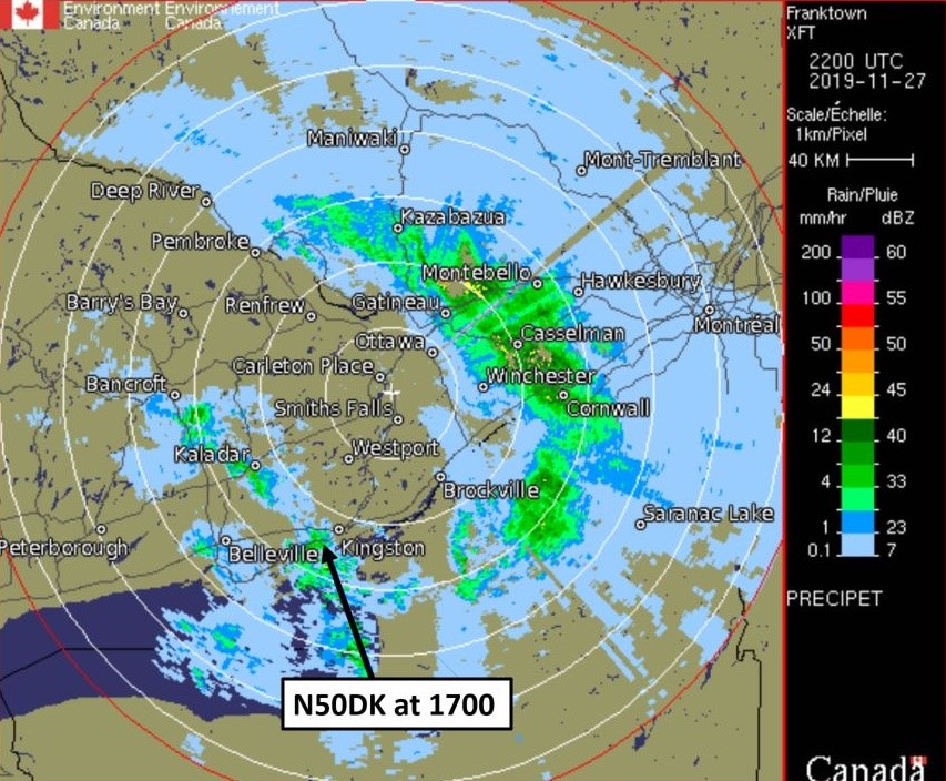
At 1700, 5 minutes before the occurrence, the CYGK METAR reported winds from 060°T at 5 knots, visibility of 5 SM due to mist, scattered cloud at 700 feet AGL, and a ceiling overcast at 4000 feet AGL. Weather radar obtained after the occurrence indicated that at 1700 there was moderate to heavy precipitation just to the west of Kingston, as the aircraft was approaching the airport (Figure 4).
Due to the cloud cover, combined with the precipitation and reduced visibility, the sky would have appeared to be dark well before official night (the end of civil twilight) began in the Kingston area, at 1702.
After the occurrence, at 1713, an aerodrome special meteorological report (SPECI) was issued, indicating variable winds at 2 knots, 3 SM visibility in light rain with mist, and that the clouds that were scattered at 700 feet AGL had become a broken ceiling at 600 feet AGL.
Following the occurrence, the TSB requested that Environment and Climate Change Canada complete a meteorological assessment.Footnote 6 The assessment indicated that in addition to the low ceilings and visibility, turbulence and low-level wind shear were likely to have been encountered at and around the site of the accident; convective cloud likely produced moderate, possibly even severe, turbulence.
An analysis of the freezing levels in the corridor between CYKZ and CYGK revealed that they ranged between 5000 and 8000 feet ASL. Icing is not likely to have been a factor in this accident since the aircraft did not fly higher than 3500 feet ASL.
1.8 Aids to navigation
The aircraft was equipped with an autopilot and 2 GPS units. The pilot also had a tablet with the ForeFlight Mobile application installed on it, which he used for flight planning and navigation.
1.8.1 ForeFlight Mobile
ForeFlight Mobile is an application for smartphones and tablets. It is used by pilots to aid in a variety of pre-flight tasks, such as flight planning (including accessing weather information), flight plan filing, accessing aviation navigational charts, and aircraft weight and balance calculations.
The application also has the capability to be used in flight, and can display aviation charts with the aircraft position depicted in real time (moving map) provided that the device being used has GPS reception.
In addition, with a compatible automatic dependent surveillance-broadcast (ADS-B) InFootnote 7 device installed, weather and traffic information can be overlaid on the moving map. As a result, pilots can use the display to navigate around areas of weather associated with precipitation and thunderstorm and access airport information, such as frequencies and field elevations, while flying. The ForeFlight Mobile application can also be used to maintain an electronic version of a pilot’s logbook.
The occurrence pilot had a Basic Plus subscription to U.S. ForeFlight, which includes navigational maps for the U.S. only, although there is some overlap in map coverage near the Canada–U.S. border. This overlap would enable the occurrence pilot to conduct the entire planned route of flight without having to purchase navigational charts for Canada.
The occurrence pilot had the ForeFlight Mobile application installed on a tablet with GPS and Wi-Fi capability, but no mobile (cellular) data. Before departure, when connected to Wi-Fi, the pilot would have been able to use the tablet for flight planning purposes, such as checking the weather, planning the route, researching airport services, etc. However, he would have lost some of that functionality when airborne: the maps and GPS navigation would have still been available, but without Wi-Fi or mobile data, he would not have had access to the same comprehensive weather information.
The aircraft was equipped with an ADS-B In receiver,Footnote 8 which has the capability to display weather and traffic information on the ForeFlight Mobile moving map display while airborne. However, because ADS-B In in the U.S. is based on receiving data from ground-based stations, aircraft need to be in range of an ADS-B ground-based station to receive this data. Because this type of system is not available in Canada,Footnote 9 the pilot would have received weather only if he had been in range of a U.S.-based ADS-B ground station.
According to the FAA ADS-B coverage map,Footnote 10 at an altitude of 1500 feet AGL, the occurrence aircraft would have had ADS-B reception for the majority of the occurrence flight. However, this reception would have diminished at lower altitudes and would have been non-existent in a small area northeast of Peterborough. Although U.S. ADS-B coverage was available, the system provides METARs and TAFs only for airports located in the U.S., not for Canadian airports. In addition, the U.S. weather radar stations used by the ADS-B system only cover areas of Canada near the border.
Consequently, the route and altitude flown by the occurrence aircraft did not have consistent weather radar coverage. According to the NOAA National Centers for Environmental Information (NCEI) radar data map,Footnote 11 at an altitude of 3 000 feet AGL, weather radar is available in the Toronto area, but ends about 9 miles west of Peterborough. It was reported that before the flight, the pilot mentioned that he did not have the same weather information available to him for flying in Canada as he did for flying in the U.S.
1.9 Communications
CYGK is located within a Class E control zone, for which a mandatory frequency exists,Footnote 12 and which extends 5 miles around the airport and to 3000 feet above aerodrome elevation. Weather information for CYGK can be obtained while airborne through the automatic terminal information service (ATIS) broadcast. At the time of the occurrence, the pilot had been communicating with the Kingston FSS (see section 1.1).
1.10 Aerodrome information
Not applicable.
1.11 Flight recorders
The aircraft was not equipped with a flight data recorder or cockpit voice recorder, nor was it required to be by regulation. Several electronic devices capable of recording data were recovered at the accident site and sent to the TSB Engineering Laboratory in Ottawa, Ontario. However, due to impact damage or device settings, only one device, a GPS, provided useful information about the occurrence flight.
The GPS data contained several flights, including the occurrence flight. An analysis of the recorded data was performed. Recorded parameters included date and time, latitude and longitude, and GPS altitude. The data was recorded at irregular intervals of 11 seconds on average. In the final 40 seconds of the data, the intervals improved significantly to about 3 seconds on average.
1.12 Wreckage and impact information
The aircraft wreckage was located in a wooded area approximately 1 NM northeast of the community of Westbrook, Ontario, and 3.5 NM north of CYGK. The elevation of the impact site was approximately 400 feet ASL.
The initial impact point was a treetop approximately 110 feet south of the shallow crater caused by the main impact with the ground. There were multiple tree strikes between the initial strike and the ground impact site. Some trees showed evidence of having been struck by the propeller, which exhibited damage consistent with a strike while under significant power.
Indeed, examination of the wreckage site indicated the aircraft struck the ground while travelling at high speed, in a steep nose-down attitude. There was no pre- or post-impact fire. Further examination of the aircraft wreckage was completed at the TSB regional facility in Richmond Hill, Ontario, and nothing was found to indicate there were any pre-impact anomalies of the airframe or engine components.
Several instruments were sent to the TSB Engineering Laboratory for examination in order to determine their respective indications at the time of impact. However, it was possible to derive information from only 2 of the instruments: the attitude indicator likely displayed a maximum nose-down attitude at the time of impact, and the vertical speed indicator likely displayed a 1900 fpm descent rate at the time of impact.
1.13 Medical and pathological information
The investigation determined that there was nothing to indicate that the pilot's performance was degraded by medical or pathological factors.
1.14 Fire
There was no post-impact fire.
1.15 Survival aspects
In this occurrence, 1 passenger was seated in the front of the aircraft, next to the pilot, and the remaining 5 passengers were seated in the rear of the aircraft.
The front-seat passenger had both the shoulder harness and lap belt fastened, while the pilot only had the lap belt portion of the safety belt fastened and was not wearing the available shoulder harness.
The aircraft was equipped with 4 seats in the back, all with lap belts only. The 4 lap belts were found unfastened. The 5 passengers seated in the back were ejected during the occurrence. As a result, it could not be determined where they were sitting exactly before the impact. It could not be determined either if any of the rear-seat passengers had their lap belts fastened earlier in the flight, such as during take-off, and had then unfastened them for the cruise portion of the flight or if they had them unfastened for the entire flight.
Although this occurrence was likely not survivable due to impact forces, the use of safety belts is widely known to reduce the risk and/or severity of injury for aircraft occupants.
The aircraft was equipped with a 406 MHz ELT, which activated on impact as designed, and aided the search and rescue personnel in locating the aircraft .
1.15.1 Safety belt regulations
The Canadian Aviation Regulations (CARs) contain several requirements for aircraft to be equipped with safety belts, restraint systems, and shoulder harnesses. More specifically, the CARs stipulate the following with respect to the requirement for seats and safety belts:
605.22 (1) Subject to subsection 605.23, no person shall operate an aircraft other than a balloon unless it is equipped with a seat and safety belt for each person on board the aircraft other than an infant.Footnote 13
With respect to the general use of safety belts and restraint systems, section 605.25 of the CARs states the following:
(1) The pilot-in-command of an aircraft shall direct all of the persons on board the aircraft to fasten safety belts
- during movement of the aircraft on the surface;
- during take-off and landing; and
- at any time during flight that the pilot-in-command considers it necessary that safety belts be fastened.Footnote 14
Further, section 605.26 of the CARs states the following:
(1) Where the pilot-in-command or the in-charge flight attendant directs that safety belts be fastened, every passenger who is not an infant shall
- ensure that the passenger’s safety belt or restraint system is properly adjusted and securely fastened;Footnote 15
In the U.S., the Federal Aviation Regulations (FARs) contain very similar requirements for the use of safety belts. The pilot-in-command is required to wear a safety belt during takeoff, landing, and while en route,Footnote 16 and the pilot’s shoulder harness must be fastened, unless it interferes with piloting duties.Footnote 17 Passengers must be notified to fasten their safety belts during surface movement, takeoff and landing,Footnote 18 and must be seated in an approved seat equipped with a safety belt. Footnote 19
In both Canada and the U.S., passengers under the age of 2 may be held by an adult who is occupying an approved seat.Footnote 20,Footnote 21 None of the passengers involved in this occurrence were under the age of 2.
1.16 Tests and research
1.16.1 TSB laboratory reports
The TSB completed the following laboratory reports in support of this investigation:
- LP279/2019 - Pitot Mast Analysis
- LP282/2019 - NVM Data Recovery
- LP001/2020 - Instrument Analysis
- LP111/2020 - Flight Analysis
1.17 Organizational and management information
Not applicable.
1.18 Additional information
1.18.1 Human factors
1.18.1.1 Pilot decision making
Pilot decision making (PDM) is a cognitive process to select a course of action between alternatives. The FAA defines aeronautical decision making as “a systematic approach to the mental process used by pilots to consistently determine the best course of action in response to a given set of circumstances. It is what a pilot intends to do based on the latest information he or she has.”Footnote 22
According to an educational package from Transport Canada (TC),Footnote 23 PDM is a function of time, so that before the flight, there is “ample-time decision making,” and while in flight, in a dynamic environment, there can be “time-critical decision making.”Footnote 24 Thorough pre-flight planning allows for informed decisions on the ground to avoid the need for potentially more difficult in-flight decisions.
For example, when planning a day/night VFR flight, it is critical to obtain all relevant weather data to make an informed decision to conduct the flight or not, and if the decision is made to undertake the flight, it can reduce the risk of flying inadvertently from VFR conditions into instrument meteorological conditions (IMC).Footnote 25 Several factors, circumstances, and biases can affect PDM, including the flight objective or goal, and the pilot’s knowledge, experience, and training,Footnote 26 and can result in a pilot operating an aircraft beyond the aircraft's capability or beyond the pilot’s abilities.
Poor risk assessment can negatively affect PDM, and risk perception and risk tolerance can subjectively affect risk assessment. A pilot may tolerate more risk to achieve a perceived important goal or objective.Footnote 27 Pilots in general aviation, particularly those with limited flying experience, can substantially underestimate weather-related risks and this can result in pilots flying into adverse or deteriorating weather.Footnote 28
1.18.1.2 Spatial disorientation
Humans have the ability to discern the orientation of their body (lying down, standing, leaning, etc.) when they are in physical contact with the ground. Humans are not accustomed to the 3-dimensional environment of flight, and conflicts may arise between the senses and illusions, thus making it difficult or impossible to maintain spatial orientation. Pilot spatial disorientation is defined as the “inability of a pilot to correctly interpret aircraft attitude, altitude or airspeed in relation to the Earth or other points of reference.”Footnote 29
Humans process information from 3 sensory systems to orient themselves in space:
- the visual system,
- the vestibular system (information from the inner ear), and
- the proprioceptive system (information from muscles, joints, and bones).Footnote 30
The visual system provides 80% of the information used for spatial orientation. If visual information is lost, all that remains is the 20% of information that comes from the vestibular and proprioceptive systems. The information from these 2 systems is less precise and more susceptible to error because they are prone to illusions and misinterpretation.Footnote 31 When visual cues from the ground are poor or non-existent, spatial disorientation can be overcome by switching to instrument flight.Footnote 32
To avoid a loss of control, pilots must be familiar with the mechanisms that lead to spatial disorientation, be aware of the potential for disorientation when visibility and ground references are reduced, and understand how to handle such a situation.Footnote 33
The Transport Canada Aeronautical Information Manual (TC AIM) describes the potential for disorientation. It refers to vision as our strongest orienting sense and stresses that when in whiteout or cloud, this sense is not available, which increases the likelihood of disorientation. It provides the following example:
For example, once a turn has been entered and is being maintained at a steady rate, the sensation of turning will disappear. Upon recovering from the turn, pilots may feel as though they are turning in the opposite direction and erroneously re-enter the turn, even causing the aircraft to enter into a spin.Footnote 34
While the conditions mentioned are whiteout and cloud, a similar lack of external visual cues and resultant disorientation can occur in darkness. Spatial disorientation can lead to loss of control of the aircraft or controlled flight into terrain.Footnote 35
1.18.2 Night visual flight rules
The flight departed CYKZ at 1601, which meant that the estimated time of arrival at CNV9 would be approximately 1900. Because official night began at 1702 in CYKZ, and at 1634 at CNV9, a significant portion of the planned flight would be undertaken in darkness under night VFR.
During the night portion of the flight, the pilot could have expected some cultural lighting from communities along his intended route, but much less in more remote areas (e.g., cottages, traffic on roads and highways). Furthermore, there were several areas of very little or no lighting and, therefore, areas with no reference to the ground or the horizon. In addition, there was little or no ambient illumination from the moon due to the cloud coverage.
Night flying involves numerous risks owing to poor visual cues, especially on takeoff and landing. The fact that there are few or no visual references at night can lead to various illusions causing spatial disorientation due to the lack of discernible horizon. Night flying in, out of, or over featureless terrain, such as bodies of water or wooded terrain, is difficult. These areas are referred to as black holes.
Flying VFR at night is more hazardous than flying VFR during the day due to human vision limitations, vulnerability to illusions, and the potential absence of external visual cues. Estimating distance from cloud and adverse weather at night or in darkness is difficult for pilots and increases the risk of inadvertent VFR flight into IMC, which can quickly result in spatial disorientation and a loss of control.
Simply put, night VFR flight inherently offers the pilot limited visual cues to be able to see and avoid worsening weather conditions. Pre-flight planning is especially important for night flights: specifically, a review of weather conditions and their corresponding impact on the intended aircraft track; the available moonlight; the estimated flight time over large bodies of water or areas with little or no cultural lighting; and the flight path’s proximity to rising terrain and significant obstacles.
While in flight, it is important for pilots to obtain weather updates and compare visual weather indications at regular intervals for visibility and proximity to cloud against expectations established in the flight-planning phase. Because it is difficult to visually detect and stay clear of terrain and obstacles at night, it is critical that pilots plan and maintain flight above the published maximum elevation figure altitudes published on VFR charts.
1.18.2.1 Visual reference to the surface
The principle behind VFR flight is that the pilot uses visual cues (e.g., visual horizon, ground references) outside the aircraft to determine the aircraft’s attitude. Therefore, some basic requirements must be met when conducting VFR flight—day or night.
According to CARs 602.114 and 602.115, the aircraft must be “operated with visual reference to the surface,”Footnote 36 regardless of whether it is operated in controlled or uncontrolled airspace. The CARs define surface as “any ground or water, including the frozen surface thereof.”Footnote 37 However, the term “visual reference to the surface” is open to interpretation, because it is not defined in the regulations. Industry has widely interpreted it to mean visual meteorological conditions.Footnote 38, Footnote 39
In addition to the requirements for visual reference to the surface, the regulations also prohibit the operation of an aircraft under VFR at night in areas where flight visibility or ground visibility, if it is reported, is less than 3 SM.Footnote 40
Therefore, a flight conducted over an area with less than 3 SM visibility or away from cultural lighting and where there is inadequate ambient illumination to have visual reference to the surface would not meet the requirements for operation under night VFR. Instead, such flight would require pilots to rely on their flight instruments to ensure safe operation of the aircraft.
Following a TSB investigationFootnote 41 into a helicopter accident in May 2013 where the flight had departed under night VFR conditions from a remote airport with minimal nearby lighting, the TSB raised concerns with the lack of clarity in the practical meaning of the definition of a “flight with visual reference to the surface.” The Board recommended that
Transport Canada amend the regulations to clearly define the visual references (including lighting considerations and/or alternate means) required to reduce the risks associated with night visual flight rules flight.
TSB Recommendation A16-08
At March 2021, the TSB’s most recent published assessment of TC’s response to Recommendation A16-08 was completed in February 2021 and was rated as Satisfactory Intent. Footnote 42
TC has indicated that it is in the process of drafting 2 notices of proposed amendment (NPAs) that would lead to updates to the night VFR requirements and changes that would require 2 levels of night rating. TC expects these NPA packages to be completed by mid-2021. TC also published an updated version of Advisory Circular (AC) 603-001 – Special Authorization for Night Vision Imaging Systems, as well as articles in issues of the Aviation Safety Letter to educate pilots and raise awareness of the risks associated with night VFR flights.
Since May 2013, the TSB has investigated 5 other fatal accidents involving private aircraft on night VFR flights, the reports of which have highlighted the lack of clarity in the regulations regarding visual references.Footnote 43
1.18.2.2 Transport Canada night rating and recency requirements
Standard 421.42 of the CARs sets out the requirements for the holder of a private pilot licence to obtain a night rating endorsement. The required experience is 10 hours of night flying (5 hours dual and 5 hours solo) and 10 hours of dual instrument time. The applicant must also successfully complete a qualifying flight with a TC inspector or qualified flight instructor and demonstrate the level of skill specified in the Flight Instructor Guide—Aeroplane.Footnote 44
For the holder of a night rating in Canada, CAR 401.05 establishes the recency requirements to exercise the privileges of flight crew licences and ratings. With respect to VFR flight at night, the only limitation specified is that, if passengers are carried, the pilot must have completed 5 takeoffs and landings at night within the previous 6 months. There is no requirement to practise or maintain instrument flying proficiency to fly VFR at night.
1.18.2.3 Federal Aviation Administration night flying requirements
Pilots in the U.S. are not required to obtain a night rating or endorsement, as night flying is included in the FAA’s flight proficiency requirements for a private pilot certificate with a single-engine airplane rating:Footnote 45
(2) Except as provided in [section] 61.110 of this part, 3 hours of night flight training in a single-engine airplane that includes—
(i) One cross-country flight of over 100 nautical miles total distance; and
(ii) 10 takeoffs and 10 landings to a full stop (with each landing involving a flight in the traffic pattern) at an airport.
(3) 3 hours of flight training in a single-engine airplane on the control and maneuvering of an airplane solely by reference to instruments, including straight and level flight, constant airspeed climbs and descents, turns to a heading, recovery from unusual flight attitudes, radio communications, and the use of navigation systems/facilities and radar services appropriate to instrument flight;Footnote 46
According to the U.S. regulations, to carry passengers during the period beginning 1 hour after sunset and ending 1 hour before sunrise, a pilot needs to have made in the preceding 90 days “at least three takeoffs and three landings to a full stop during the period beginning 1 hour after sunset and ending 1 hour before sunrise.”Footnote 47
Based on his logbook, the pilot met these requirements.
1.19 Useful and effective investigation techniques
Not applicable.
2.0 Analysis
The investigation found no deficiencies or anomalies with the mechanical operation of the aircraft. The pilot was qualified for the flight, and there is no indication his performance was degraded by medical or pathological factors.
Therefore, in an effort to understand why this accident happened, the analysis will focus on the following areas: the pilot’s decision making, including pre-flight planning and the effect of experience; night visual flight rules (VFR) flight; inadvertent flight into instrument meteorological conditions (IMC); the operation of aircraft that exceed the maximum permissible take-off weight; and safety belt use.
2.1 Decision making
2.1.1 Pre-flight planning
Before departing on a VFR flight, it is important for pilots to review all relevant weather reports and forecasts. This thorough pre-flight planning allows for informed decisions on the ground to avoid the need for potentially more difficult in-flight decisions.
In this occurrence, the pilot checked the weather using the ForeFlight Mobile application before departure. The graphical weather products viewed on the pilot’s ForeFlight Mobile account were of a scale that covered the entire continental United States (U.S.). The weather shown on these charts did, however, depict weather over the intended area of the occurrence flight, which closely adjoined the Canada–U.S. border. Some of the charts that the pilot viewed indicated that there would be a low-pressure system associated with mixed precipitation and possible low ceilings and reduced visibility along large portions of the intended route of flight, including the destination.
Although other localized weather products, such as aerodrome routine meteorological reports (METARs) and aerodrome forecasts (TAFs) were available on ForeFlight during his pre-flight planning using Wi-Fi, it could not be determined if the pilot accessed this information. In addition, it could not be determined if the pilot checked other sources of weather information before departure. These sources of weather, including the relevant METARs and TAFs, would have indicated that the conditions were forecasted to be below the minimum required for night VFR flight.
Finding as to causes and contributing factors
The pilot departed Toronto/Buttonville Municipal Airport (CYKZ), Ontario, when the weather conditions for the intended flight were below the limits required for a night VFR flight.
2.1.2 The effect of experience
While the pilot was qualified for the flight, he had held his private pilot certificate for only a short period of time. He did not have an instrument rating, and had only limited experience flying at night. Most of the pilot’s flying experience was conducted in Texas, where the climate is significantly different from Canada’s, and where he would have had greater access to weather information on his tablet while airborne.
It could not be determined if the pilot was referring to the ForeFlight Mobile application during the occurrence flight, but it was reported that he commonly used it for navigating and displaying weather information while flying. However, during the occurrence flight, because the system relies on automatic dependent surveillance-broadcast (ADS-B) In and because ADS-B In is not available in Canada, he would not have had access to the weather products that he was used to in the U.S., such as weather radar, METARs and TAFs.
Pilots in general aviation, particularly those with limited flying experience, can substantially underestimate weather-related hazards and risks that they have not previously encountered, which can result in pilots flying into deteriorating weather conditions.
Even though the pilot had reviewed some weather sources before the occurrence flight, considering his limited flying experience, including flying at night, he was likely not fully aware of the hazards associated with the flight. These included operating the aircraft at night without the benefit of live weather updates from ADS-B through ForeFlight, in areas with poor weather that were unfamiliar to him, and in weather that would be difficult to assess once airborne, given the limited visual cues available.
Finding as to causes and contributing factors
Given the pilot's limited flying experience, it is likely that he did not recognize the hazards associated with the night VFR flight into poor weather conditions.
2.2 Night visual flight rules flight
The aircraft departed during daylight hours; however, a significant portion of the planned flight was to be conducted under night VFR. Because it can be difficult to estimate their distance from clouds and adverse weather during the hours of darkness, pilots may inadvertently fly into them, which can result in spatial disorientation, especially for pilots with very little instrument training or without an instrument rating.
The flight was planned over areas that had very little or no cultural lighting at times; therefore, the pilot would have had no reference to the ground during portions of the flight.
Although the area of the collision with terrain was surrounded by cultural lighting, there would have been little or no illumination from the moon, and the pilot would have had difficulty seeing outside visual references owing to a combination of darkness and adverse weather conditions.
The Canadian Aviation Regulations (CARs) require the pilot to maintain visual reference to the surface for night VFR flight, but do not define "visual reference to the surface." As identified in TSB Recommendation A16-08, this term has been widely interpreted by the industry to mean visual meteorological conditions, which are based on visibility and distance from cloud.
Finding as to risk
If the CARs do not clearly define what is meant by “visual reference to the surface,” night flights may be conducted with inadequate visual references, which increases the risks associated with night VFR flight, including controlled-flight-into-terrain and loss-of-control accidents.
2.3 Inadvertent flight into instrument meteorological conditions
After flying for approximately 30 minutes in the general direction of Québec/Neuville Airport (CNV9), Quebec, the aircraft descended and turned to a southeasterly direction toward Kingston Airport (CYGK), Ontario. This manoeuvre was likely in response to encountering poor weather conditions. Weather radar images obtained after the occurrence confirm that there was precipitation in the area at the time, and. the METAR for a nearby station also reported low ceilings and reduced visibility.
After the pilot contacted the CYGK flight service station and indicated his intention to land on Runway 19, he began to descend and slow down, which denotes the beginning of an approach. During his final radio call, he correctly reported his position 2.5 nautical miles (NM) north of the airport, demonstrating that he had some awareness of his horizontal location; he did not convey any sense of urgency.
It is unclear why the pilot then made a left turn away from the airport. However, it is likely that while manoeuvring for landing and attempting to locate the airport visually in the poor weather conditions, the aircraft entered a cloud or area of reduced visibility and the pilot lost visual reference to the surface. In these circumstances, it would have been difficult for the occurrence pilot to correctly interpret the aircraft’s attitude, altitude or airspeed.
Vision is our strongest orienting sense, and when pilots lose this sense by losing outside visual references, the likelihood of disorientation is greatly increased. Spatial disorientation can be overcome by switching to instrument flight. However, the pilot did not have an instrument rating, and had little experience flying with instruments. With only limited instrument flight experience and limited outside visual cues, the pilot likely became spatially disoriented, which led to the initiation of a steep climb and the aircraft commencing a roll from a left bank to a right bank.
At this point, the pilot lost control of the aircraft, the airspeed dropped well below the stall speed, and a rapid descent ensued. The aircraft rolled inverted into a steep nose-down attitude before impacting the ground.
Finding as to causes and contributing factors
While the aircraft was approaching CYGK, the pilot likely lost visual reference to the surface, became spatially disoriented, and lost control of the aircraft.
2.4 Operation of aircraft that exceed the maximum permissible take-off weight
In this occurrence, the aircraft departed with about 500 pounds of fuel, 7 occupants, and at least 135 pounds of cargo on board. A review of the total weight on board the aircraft indicated that the aircraft was approximately 200 pounds over the maximum permissible take-off weight when it departed from CYKZ. At the time of the occurrence, based on fuel consumption estimates, the aircraft was still approximately 100 pounds overweight.
Documentation of a weight and balance calculation was not located; however, it was reported that the pilot was aware of the aircraft weight limitations, and would often perform a mental calculation to ensure the weight was within limits.
Finding as to risk
If aircraft are operated in excess of the maximum permissible take-off weight, there is a risk of performance degradation and adverse flight characteristics, which could jeopardize the safety of the flight.
2.5 Safety belt use
The regulations related to the use of safety belts are similar in Canada and in the U.S. Both the CARs and the Federal Aviation Regulations require passengers to wear safety belts during ground movement, takeoff, and landing, but not during the en-route portion of the flight.
Although the aircraft was equipped with only 6 seats and 6 safety belts, the flight was conducted with 7 occupants, none of whom were young enough to be carried by another seated passenger. The 4 safety belts in the rear of the cabin were not fastened during the impact. Shortly before the collision with terrain, the aircraft was approaching CYGK for a landing, which is when the pilot was required to direct the passengers to fasten their safety belts. It could not be determined why the rear seat passengers were not wearing the belts, or if they had them fastened earlier in the flight.
In addition, the pilot was not wearing the available shoulder harness at the time of impact. Although this occurrence was likely not survivable due to impact forces, the use of safety belts and shoulder harnesses is widely known to reduce the risk and/or severity of injury for aircraft occupants.
Finding as to risk
Passengers who are not adequately restrained during an accident are at greater risk of receiving serious or fatal injuries than passengers who are adequately restrained.
3.0 Findings
3.1 Findings as to causes and contributing factors
These are conditions, acts or safety deficiencies that were found to have caused or contributed to this occurrence.
- The pilot departed Toronto/Buttonville Municipal Airport, Ontario, when the weather conditions for the intended flight were below the limits required for a night visual flight rules flight.
- Given the pilot's limited flying experience, it is likely that he did not recognize the hazards associated with the night visual flight rules flight into poor weather conditions.
- While the aircraft was approaching Kingston Airport, the pilot likely lost visual reference to the surface, became spatially disoriented, and lost control of the aircraft.
3.2 Findings as to risk
These are conditions, unsafe acts or safety deficiencies that were found not to be a factor in this occurrence but could have adverse consequences in future occurrences.
- If the Canadian Aviation Regulations do not clearly define what is meant by “visual reference to the surface,” night flights may be conducted with inadequate visual references, which increases the risks associated with night visual flight rules flight, including controlled-flight-into-terrain and loss-of-control accidents.
- If aircraft are operated in excess of the maximum permissible take-off weight, there is a risk of performance degradation and adverse flight characteristics, which could jeopardize the safety of the flight.
- Passengers who are not adequately restrained during an accident are at greater risk of receiving serious or fatal injuries than passengers who are adequately restrained.
4.0 Safety action
4.1 Safety action taken
The Board is not aware of any safety action taken following this occurrence.
This report concludes the Transportation Safety Board of Canada’s investigation into this occurrence. The Board authorized the release of this report on . It was officially released on .