Collision with terrain
Mooney M20C
Slave Lake Airport, Alberta, 12 NM N
The Transportation Safety Board of Canada (TSB) investigated this occurrence for the purpose of advancing transportation safety. It is not the function of the Board to assign fault or determine civil or criminal liability. This report is not created for use in the context of legal, disciplinary or other proceedings. See Ownership and use of content. Masculine pronouns and position titles may be used to signify all genders to comply with the Canadian Transportation Accident Investigation and Safety Board Act (S.C. 1989, c. 3).
History of the flight
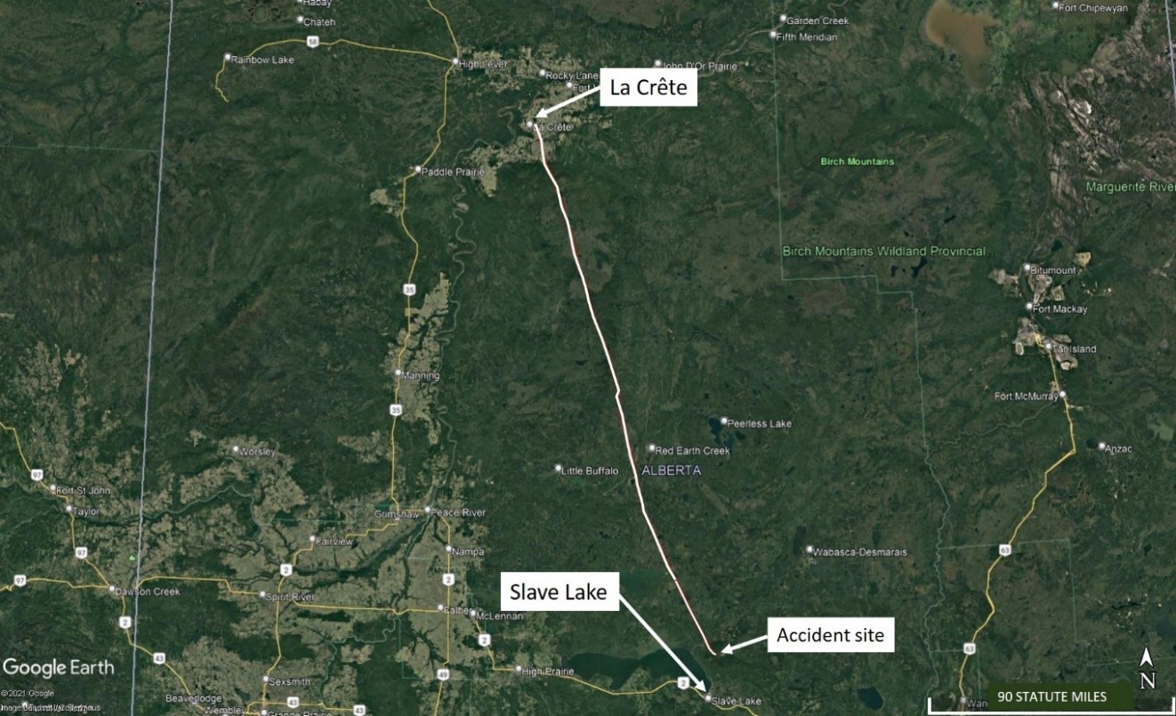
On 31 August 2021, the privately registered Mooney M20C aircraft (registration C-GTIJ, serial number 2901) was conducting a visual flight rules (VFR) flight from La Crête Aerodrome (CFN5), Alberta, to Saskatoon/John G. Diefenbaker International Airport (CYXE), Saskatchewan. The pilot was the sole occupant on board.
At 0816,Footnote 1 the pilot called the Edmonton Flight Information Centre to file his VFR flight plan. The planned route was from CFN5 to Slave Lake Airport (CYZH), Alberta, then to Lloydminster Airport (CYLL), Alberta, and finally to CYXE. The planned altitude for the flight was 5500 feet above sea level (ASL). During the call, the flight service specialist offered to provide a weather briefing, but the pilot declined and informed the specialist that he had already retrieved weather information for the airports along the route and concluded that the conditions met VFR minima; however, he recognized that it might not be possible to reach his planned altitude owing to clouds.
The pilot had a tablet on board with a current subscription to a commercially available flight planning program. The investigation was unable to confirm whether or not the pilot used that program to obtain weather information. However, the investigation revealed that the pilot called his family before departure and told them that he was aware of poor weather on his planned route, but that he would work his way around it. He had flown this route many times.
The aircraft departed at 0900 in visual meteorological conditions and initially climbed to 3500 feet ASL on a southerly heading (figures 1 and 2). Along the route to CYZH, the aircraft reached an altitude of 4000 feet ASL before descending, likely due to cloud ceilings. When the aircraft was 14 nautical miles (NM) north of CYZH, the pilot changed the destination in the GPS (global positioning system) from CYZH to CYLL. The aircraft’s track then turned to the east toward CYLL and toward rising terrain. At this time the aircraft was at 3000 feet ASL or 500 feet above terrain.
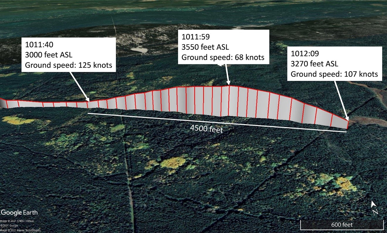
At 1011:40, the aircraft climbed to 3550 feet ASL and its ground speed decreased from 125 knots to 68 knots. The aircraft then started a descent at 1011:59 and descended until shortly after 1012:09, when it impacted terrain in a wooded area at approximately 3200 feet ASL (Figure 3). GPS data from the digital engine monitorFootnote 2 showed that the aircraft’s descent angle before it hit trees was about 15°. The average descent rate was 1680 fpm until a few seconds before impact, when it increased to over 2000 fpm. The pilot was fatally injured. The aircraft was destroyed. The emergency locator transmitter activated.
Given the weather conditions, search and rescue (SAR) aircraft, based at Slave Lake and Cold Lake, Alberta, as well as Comox, British Columbia, were grounded at the time of the occurrence and an air search of the area was not possible. As a result, first responders could not locate the site on the day of the occurrence. The accident site was located the next day, and was reached by SAR technicians 2 days after the occurrence.
Pilot
The pilot held a private pilot licence and his Category 3 medical certificate was valid. He had obtained an instrument rating in 1979. Records indicate that he had not exercised the instrument rating privileges in the preceding 5 years and did not meet the recency requirements to do so.
Records also indicate that the pilot had accumulated approximately 2800 hours of flying time, 1259 of which were in the occurrence aircraft or other Mooney M20 aircraft.
Aircraft information
The Mooney M20C is a low-wing, single-engine, 4-seat, general aviation aircraft with retractable tricycle landing gear. The occurrence aircraft was manufactured in 1964.
The investigation did not identify any issues related to aircraft equipment, maintenance, or certification that would have prevented the aircraft from operating normally during the occurrence flight.
The occurrence aircraft was equipped with a Garmin GNS430 GPS. In addition to navigation data, this unit has the capability to provide pilots with visual terrain advisories; however, it is not certified as a terrain awareness and warning system in accordance with technical standing order CAN-TSO-C151d.Footnote 3 The investigation was unable to determine whether or not this feature was in use at the time of the occurrence.
The aircraft was not equipped with a flight data recorder or a cockpit voice recorder, nor was it required to be by regulation.
Impact and wreckage information
The area around the accident site was heavily treed. Damage to the aircraft is consistent with the aircraft striking trees in a right-wing-low attitude. Following the impact with the trees, the right wing tip broke off and the aircraft continued to the ground on an 18° trajectory. The aircraft collided with the ground about 45 feet from where it first struck the trees. This impact is consistent with a loss of control of the aircraft.
The aircraft’s instruments were found either in the instrument panel or in the wreckage near the panel. The altimeter was set to 29.69 inches of mercury (inHg).Footnote 4 The investigation determined there were no signs of pre-impact mechanical failure or system malfunction. The damage to the engine and propeller indicates that power was being produced during the impact sequence. There was no indication of fire in the wreckage.
Weather
There is no weather reporting at CFN5. At the time of departure, the aerodrome routine meteorological report (METAR) issued at High Level Airport (CYOJ), Alberta, the nearest reporting station (32 NM to the northwest of CFN5), indicated:
- wind from 360° true (T) at 9 knots
- visibility 15 statute miles (SM)
- broken ceiling at 11 000 feet above ground level (AGL), overcast cloud layer at 26 000 feet AGL
- temperature 11 °C, dewpoint 8 °C
- altimeter setting 29.86 inHg
The aerodrome forecast (TAF) issued at 0639 indicated that conditions at CYZH at 0900 would be:
- wind from 050°T at 8 knots
- visibility 6 SM in light rain and mist
- scattered cloud layer at 800 feet AGL, overcast ceiling at 1200 feet AGL
Temporarily between 0900 and 1900 on the day of the occurrence, the TAF indicated:
- visibility 3 SM in light rain showers and mist
- broken ceiling at 800 feet AGL, overcast cloud layer at 1200 feet AGL
There was a 30% probability during this time frame for visibility of 3 SM in thunderstorms, rain, and mist, and an overcast ceiling at 2000 feet AGL with embedded cumulonimbus clouds.
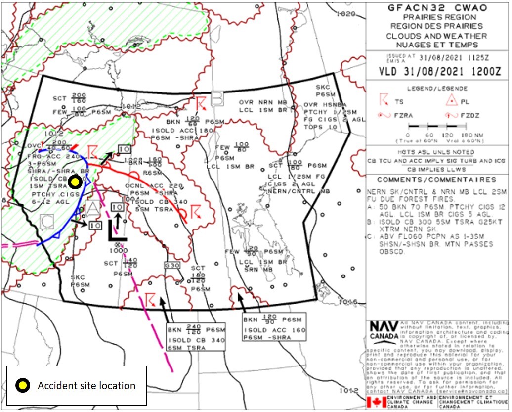
The forecast for the route indicated on the graphic area forecast (GFA) (Figure 4) was:
- overcast cloud ceilings between 4000 and 6000 feet ASL with tops at 20 000 feet ASL
- frequent altocumulus castellanus clouds with tops at 24 000 feet ASL
- visibility 3 SM to more than 6 SM in rain showers or light rain showers with mist
The GFA also indicated isolated cumulonimbus clouds with tops at 34 000 feet ASL giving visibilities of 1 SM in thunderstorms, rain, and mist. During those periods patchy cloud ceilings were expected between 600 and 1200 feet AGL.
At the time of the occurrence, the automated weather observation system (AWOS) at CYZH (12 NM to the southwest of the accident site) reported:
- wind from 270°T at 6 knots
- visibility 9 SM
- overcast ceiling at 1500 feet AGL
- temperature 13 °C, dewpoint 12 °C
- altimeter setting 29.68 inHg
Visual flight rules in deteriorating weather conditions
The hazards associated with continuing VFR flight into instrument meteorological conditions are well documented. According to data collected by the TSB from 2000 to 2019, accidents involving flights that depart under visual meteorological conditions and continue to a point where pilots lose visual reference with the ground have a high number of fatalities. Over this 20-year period, these types of accidents resulted in 115 fatalities.
TSB laboratory reports
The TSB completed the following laboratory reports in support of this investigation:
- LP108-2021 – NVM Recovery - iPad
- LP113-2021 – Log book Restoration
- LP116-2021 – NVM Recovery - Digital Engine Monitor
- LP146-2021 – Instruments Analysis
Safety message
Pilots are reminded that flying VFR in marginal weather conditions, such as low ceilings, is challenging, especially when flying over rising terrain. Pilots need to plan ahead and consider strategies to avoid adverse weather, as well as have alternate plans should such weather be encountered. VFR flights that continue into instrument meteorological conditions often result in a fatal collision with terrain or a loss of control due to lost visual references.
This report concludes the Transportation Safety Board of Canada’s investigation into this occurrence. The Board authorized the release of this report on It was officially released on


