Grounding and hull damage
the bulk carrier Algontario
at Johnson Point
St. Marys River, Ontario
The Transportation Safety Board of Canada (TSB) investigated this occurrence for the purpose of advancing transportation safety. It is not the function of the Board to assign fault or determine civil or criminal liability. This report is not created for use in the context of legal, disciplinary or other proceedings. See Ownership and use of content. Masculine pronouns and position titles may be used to signify all genders to comply with the Canadian Transportation Accident Investigation and Safety Board Act (S.C. 1989, c. 3).
Summary
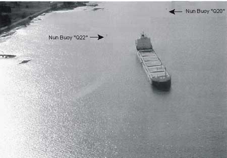
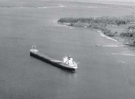
In the early morning of 5 April 1999, the Algontario was upbound in the St. Marys River. With the vessel abeam of Johnson Point light, the helm was put "hard to port" to make a 63° alteration of course into the Middle Neebish Channel. The vessel's turning circle increased and the rate of turn decreased due to squat and bank suction effects. The vessel overshot the turn for the deep channel and grounded in the 6.4 m (21 ft.) project depth channel between buoys Q20 and Q22. The channel was closed to upbound traffic until the vessel was refloated. Underwater surveys revealed that the hull suffered extensive damage to the bottom plating. The vessel was later dry-docked for temporary repairs.
Factual information
| Name | "ALGONTARIO" |
|---|---|
| Official Number | 320490 |
| Port of Registry | Toronto, Ontario |
| Flag | Canada |
| Type | Gearless bulk carrier |
| Gross Tonnage | 18,883 |
| Length Breadth |
222.5 m 23.1 m |
| Draught | Forward: 6.6 m Aft: 7.8 m (prior to grounding) |
| Built | Aft section: Schlieker Werft, Hamburg, Germany, 1960 Forward section: Davies Shipbuilding, Lauzon, Canada, 1977 |
| Propulsion | Burmeister & Wain, diesel engine 6,476 kilowatts, with controllable-pitch propeller |
| Number of Crew | 23 |
| Registered Owner | Algoma Central Marine, St. Catharines, Ontario |
Description of the vessel
The Algontario is a gearless bulk carrier with the machinery space, crew accommodation, and navigation bridge located aft. The vessel has six holds, with water ballast tanks abreast each hold. Double bottom tanks throughout the length of the cargo holds are subdivided by the centreline girder. The vessel is equipped with main engine bridge controls. The maximum open water speed is 12.5 knots.
History of the voyage
On 2 April 1999, the Algontario departed the St. Lawrence Cement dock at Clarkson, Ontario, bound for Duluth, Minnesota, with a load of 18,910 tonnes (t) of bulk cement. The vessel had 382 t of heavy fuel oil and 98 t of diesel on board. It was the master's first upbound voyage of the season on the lakes. The voyage was proceeding normally and without incident. All the mechanical, electrical, and navigation systems were operating satisfactorily.
On April 5, at 0209 Eastern daylight time, four miles before the Detour Reef Light, the master was called to the bridge to take control of the navigation. The bridge watch was made up of the master, the officer of the watch (OOW), and the helmsman. The master was piloting the vessel visually, and he used the Electronic Chart Display Information System (ECDIS). He opted not to use the echo-sounder while navigating in the river. At 0221 the Algontario passed Detour Reef Light and entered the St. Marys River. At 0345 the deck watch was changed. The new helmsman took the wheel while the vessel was on a course of 308°T (Course 10). The night was clear and visibility was good; winds were light from the east at 10 knots; sunrise was at 0710.
As shown on the ECDIS print out, at 0409 the ship's speed over the ground (SOG) was reduced from 10.9 to 7.2 knots (Position 5 on the throttle), as the vessel approached Mud Lake Junction buoy. The gyro was checked on Winter Point and had no error. The vessel's position was reported to the United States Coast Guard (USCG) Vessel Traffic Services (VTS), known as "Soo Control." At about 0435 the Algontario was steering on the Sailor's Encampment Range lights (Course 9) in the 8.23 m (27 ft.) project depth lane of the Neebish Channel. There was no ice or traffic reported in the vicinity of the vessel.
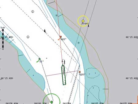
At 0434 the vessel passed buoy Q16 with an SOG of 7.5 knots. The helmsman steered the vessel using the Sailor's Encampment range lights, 017°T, using the left-hand-side range. At 0436 the speed had decreased to 7.4 knots at buoy Q18 and to 7.1 knots at 0438. At 0439, more than half the ship's length had passed Johnson Point light, which was approximately 60 m to port. The ship's heading was 015°T, and the SOG was 7.2 knots. The master called Soo Control at the winter calling-in point near Johnson Point. The mate noted the position in the log book. The engine speed was then increased to Position 6 on the throttle. At 0440, after the master ordered "Come to Port" when Johnson Point light was abreast of the bridge window, the helmsman immediately put the helm hard to port and the rudder angle indicator followed. The bow started to swing to port, as confirmed by an ECDIS heading of 354°T (see Appendix B, Figure 1).
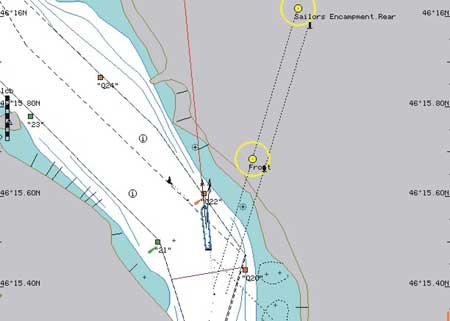
The master monitored the rate of turn as the bow started swinging to port. The mate left the port side of the bridge to go to the chart table to mark the vessel's position off Johnson Point. He glanced at the rudder indicator on his way, confirming its hard to port reading. Using the searchlight, the master located buoy Q22 ahead and it appeared to him that the vessel had a rate of turn slower than normal. The engine speed was then increased to Position 7. The helmsman also felt that the turn was slower than usual (see Appendix B, Figures 2 and 3), but this was not brought to the attention of the bridge team.
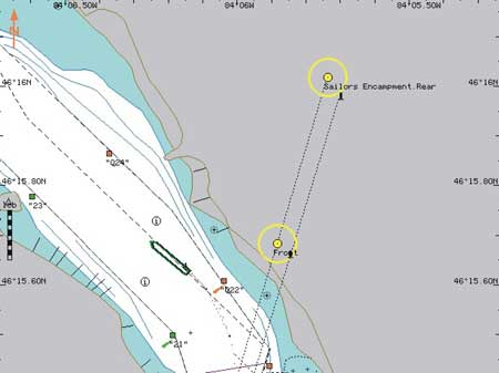
The vessel continued to turn to port but also drifted to starboard into the shallow channel. When the mate felt the vessel shudder, he left the chart table to go to the bridge front window. There was no reported discrepancy between ship time and ECDIS time (see Appendix B, Figures 4, 5, and 6).
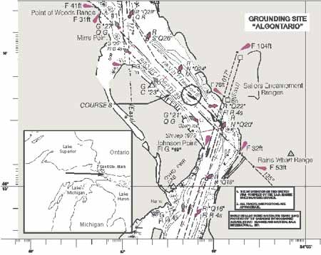
At 0443 the vessel grounded on a heading of 310°T in the 6.40 m (21 ft.) project depth section of the Middle Neebish Channel, 50 m on the Canadian side of the Canada-United States border, near buoys Q20 and Q22, in the following position: latitude 46°15.6′ N, longitude 084°06.1′ W.Footnote 1 The starboard side of the vessel was hard aground from No 5 double bottom tank aft to the rudder skeg. The engine was stopped immediately. The ship came to rest with a three-degree starboard list. The grounding took place where Course 9 and Course 8 intersect in the upbound channel.
At 0450 the master advised Soo Control of the situation. He then ordered the mate and helmsman to take soundings in the water ballast tanks (WBT) to assess flooding of the compartments and to monitor water depths and draughts around the vessel. The fuel tanks were also sounded. The depths on the starboard side were observed to be 6.83 m forward and 7.62 m aft. Depth over the stern was 7.31 m on the starboard side and 8.23 m on the port side. The tanks showing an ingress of water were WBT No 5 starboard, WBT No 6 starboard, and the port and starboard engine-room void spaces. There was no change in the soundings or ullage of any of the fuel tanks in the engine room; however, the cofferdams were filled with water. Pollutants were not released. The ship emergency plan was put into effect. Since there was a potential release of fuel and diesel oil in an area that is environmentally sensitive, containment services were contracted to the Eastern Canada Response Organization. An oil boom was deployed around the stern of the vessel. The USCG closed the Middle Neebish Channel pending full appraisal of the environmental situation.
Damage to the vessel
A diving inspection revealed that the ship was resting on a mud, gravel, and rock bottom, the stern frame skeg was resting on boulders, and the rudder was clear. The diving inspection and subsequent dry-dock survey indicated that the vessel had sustained extensive bottom shell plating damage. Starboard double bottom water ballast tanks Nos 4, 5, and 6 and the feed water tank and cofferdams in way of the engine room were breached.
Salvage Operations
The owners's salvage team arrived on the scene at 1730. The USCG inspected the vessel and requested a detailed salvage plan, approved by a naval architect, before the start of salvage operations. The salvage engineer considered that lightering was essential to refloat the vessel. Based upon the plan, it was decided to remove all ballast water from the remaining intact ballast tanks and to transfer bunker C fuel to a barge to lighten the ship.
At 0733, on April 7, lightering operations began in the presence of representatives of the USCG, Transport Canada (TC) and Environment Canada. The Algontario floated free at 1830 that evening.
Vessel certification
The vessel had been inspected by TC at Hamilton, Ontario, on 30 March 1999 and met the certification, crewing, and equipment requirements for that class of vessel and its area of operation.
Personnel Qualifications, Experience and Fitness
The master held a Coastal Navigation 1 (CN 1) certificate issued in Toronto in 1980. He had 11 years of service as a master with Algoma and had started his fifth season on the Algontario. He was qualified to navigate on the Great Lakes and he had made several voyages on the St. Marys River. During the winter months, he was used to a regular night's rest. He considered himself to be well-rested and fit for his duties; this was his first trip of the year.
The chief officer had been going to sea since 1967. He held a CN 2 certificate issued in St. Catharines in 1997, and had been working for the company since March 1998, and had been serving in this capacity for nearly five years on other vessels. He reported that he was well rested and felt fit for his duties.
The helmsman had over 15 years of experience as helmsman and worked mainly on the Great Lakes. He held a Bridge Watchman Certificate. He also reported being well rested and alert for his duties.
The second engineer held the appropriate engineer qualifications. He was on watch in the engine-room and did not notice or experience any mechanical problems.
Circadian Rhythms and Performance
The master's circadian rhythm was somewhat affected by his watch on the bridge after departing Clarkson and while transiting the Welland Canal for 12 hours. Also, it took close to 10 hours to navigate the Detroit and St. Clair River system at night. Finally, he took the con at the entrance of the St. Marys River shortly after 0200 on April 5.
In normal conditions, the sleep/wake cycle follows a 24-hour rhythm, with approximately one third of this time spent sleeping. The cycle is not the same for everyone, and the main peak of alertness can occur earlier or later in the day. Although individual rhythms vary, everyone experiences two distinct "peaks" and "troughs." The big trough is at night, with the time of a person's lowest alertness in the hours just before dawn, between 0300 and 0500; the other trough occurs in the mid-afternoon, between 1500 and 1700. During the troughs, it can be particularly difficult to maintain alertness. Preceding these maximum sleepiness periods, people have maximum wakefulness periods or "peaks". The grounding occurred between 0300 and 0500, i.e. during what was likely the crew's alertness trough.
Neebish Channel
The West and Middle Neebish channels are strategically important waterways between Lake Huron and Lake Superior. The original deepening of the St. Marys River was completed by the U.S. Army Corps of Engineers as a result of the Boundary Waters Treaty dated 1957. The Middle Neebish Channel was cut and dredged by means of explosives. Rock debris was removed and piled on the canal banks. The river bottom remains hard and rocky. Since the construction of a downbound channel on the west side of Neebish Island, the east-side channel is now a one-way channel for upbound vessels. Although several sections of the Neebish channel lie in Canadian waters, the Canadian Coast Guard (CCG) has never conducted any dredging activities on these sections. The channels of the St. Marys River meet the CCG Canadian Waterways National Manoeuvring Guidelines.
The following information is widely available to mariners, through various sources, including US chart number 14883 and the Canadian Sailing Directions Volume 2. The United States Coast Pilot for the Great Lakes, Volume 6 describes the Neebish Channel as follows:
The dredged channel of the St. Marys River divides to lead around Neebish Island. The upbound channel to the east and north sides of Neebish Island is 17.5 miles long. The courses through this stretch are well marked by lighted ranges and buoys. Course 9 leads 3.6 miles NNE to Johnson Point on the SE side of Neebish Island. The E side of the Channel has a depth of 21 feet for a width of 200 feet. The W side has a depth of 27 feet for at least 300 feet. The west side is marked by a 016° 55′ lighted range at the upper end. Course 8 leads NW for 1 mile from Johnson Point to Mirre Point. The NE side of the channel has a depth of 21 feet for a width of 400 feet and the SW side has a depth of 28 feet for a least width of 600 feet. The deep side of the channel is marked by a 134° 56′ lighted range at the lower end and a 314° lighted range at the upper end.
A USCG survey confirmed that buoys Q20 and Q22 were in their normal positions. After the refloating operations, the U.S. Army Corps of Engineers conducted a sounding survey to find if there was a hidden danger near Johnson Point. It was found that the deep and shallow draught channels conformed to their respective controlling depths of 8.54 m and 6.40 m, and that their actual physical depths at the time were approximately 0.03 m greater.
Navigation and Steering Equipment
The Algontario was equipped with the required navigation equipment and also fitted with a modern ECDIS (model Navi-Sailor 2400S). The replay of the ECDIS data provided graphic information that helped in determining the vessel's track before grounding.
The vessel is steered from a centreline console with good visibility forward. The single rudder steering system is controlled by two steering pumps. The times for "hard over" to "hard over" are 20 seconds in "hand" mode and 22 seconds in "non-follow up" mode. Both steering motors were tested before departure from Clarkson. It was the practice to have both steering motors running before entering a narrow waterway. Following the grounding, United States and Canadian inspectors tested the steering and found it responding normally. There was no indication of steering gear malfunction.
Vessel Traffic Services (VTS)
VTS have been established in the St. Marys River to prevent collisions and groundings, to protect improvements to the waterway, and to protect the navigable waters from environmental damage. The VTS station regulates the routing and movement of vessels. Participation in St. Marys VTS is mandatory for vessels at least 40 m long. There is a 7.8-knot speed limit in effect between Everens Point and Reed Point.Footnote 2 Johnson Point is a calling-in point only in winter.
There were 22 upbound vessels with a draught of 6.4 m or more that turned at Johnson Point between April 2 and April 5. On April 2 the bulk carriers James R. Baker and Candian Enterprise negotiated the turn with a 7.5-m (24 ft. 6in.) draught. The day before the grounding, at 0757, the Algosoo passed through with a draught of 6.6 m and, at 2106, the St. Clair reported upbound at Johnson Point with a draught of 6.4 m. With an after static draught of 7.8 m, the Algontario was the deepest draught vessel to pass Johnson Point in early April 1999.
Pilotage Waters
By international agreement between the United States and Canada, the waters of the Great Lakes and the St. Lawrence River have been divided into designated and undesignated pilotage waters. All waters of the St. Marys River are part of District 3. The Western Great Lake Pilots Association provides pilotage service for ocean vessels. The Great Lakes Pilotage Regulations do not require a ship-specific exemption. The ship masters and officers were exempted from pilotage requirements.
Water Level Fluctuations and Currents
According to the pilot book, the water levels of the Great Lakes are subject to three types of fluctuations: seasonal, long-range, and short-period. In the spring of 1999, long-range and seasonal water fluctuations affected Lake Superior, and water levels were reported to be lower than normal. Since 1900, the difference between the highest and the lowest monthly mean levels below the Sault Ste. Marie locks has been about 1.8 m. Changes in level have a direct effect on the available depth in the channel.
The depths of water in the dredged channels on the St. Marys River are known as the Federal project depths. The U.S. Army Corps of Engineers makes periodic bar sweeps through all the dredged reaches of the St. Marys River, and any depths found to be less than the project depths are published in the Local Notice to Mariners.
According to the VTS St. Marys River, at 0443 on the morning of the grounding, the lower pool was one inch above datum.Footnote 3 The lower pool is a gauge level used to represent the general area below the Sault locks.
The strength of the current depends largely upon the discharge of the river and the elevation of the water surface at the mouth of the river. At the time of the grounding, the St. Marys River was discharging water at a low water flow rate of 1560 m³/sec. The current around Johnson Point (Course 9) was estimated to have been approximately 2 knots.
Bridge Resource Management (BRM) Practices
The Board has previously noted that poor communication on the bridge, interrupted procedures, lack of situational awareness, and lack of teamwork continue to be factors in occurrences. Consequently, the Board has emphasized the need for improved teamwork to advance safe navigation. In 1995 the Board released a Safety Study of the Operational Relationship Between Ship Masters/Watchkeeping Officers and Marine Pilots which identified safety deficiencies associated with the lack of teamwork on the bridge, including communication between marine pilots, masters, and watchkeeping officers. In the study, the Board recommended that TC require that the initial training syllabus for all ship officers be modified to include demonstration of skills in BRM (M95-09, issued October 1995); and that TC require all ship officers to demonstrate BRM skills before being issued Continued Proficiency certificates (M95-10, issued October 1995).
In response, TC has developed a BRM Training Standard in collaboration with ship owners, marine schools, pilotage authorities, and officer unions. The finalized document is contained in TP 13117. Canadian and American marine training institutions are already providing BRM training to Canadian officers. Although BRM training is not mandatory in Canada, in 1996 and 1997 the master and the first officer of the Algontario had taken a course in BRM at Marine Safety International in Newport, Rhode Island.
Squat and Bank Suction Effects
As a vessel moves ahead in a restricted shallow channel, the flow of water under the hull is accelerated and causes a reduction in pressure such that the vessel settles deeper than her static draught. This phenomenon, known as squat, depends upon a ship's speed, the ratio of her static draught to the channel depth, and the relationship of the cross sectional areas of the hull and the channel. The depth of the squat increases with the square of the speed; loaded vessels with limited static under-keel clearance (UKC) may settle, make bottom contact, and incur grounding damage when proceeding at too high a speed.
A reduction in speed will lessen the effect of squat. When the speed of the vessel is such that some UKC is retained and bottom contact is not made, the hydrodynamic effect of the squat continues to affect the vessel's trim and have a detrimental effect on her handling characteristics. The detrimental effects include increased wave making - especially at the forward end - which generally causes the vessel to become sluggish and slower to manoeuvre.
Bank suction effect is similar to squat, but acts in the horizontal rather than vertical plane. As a vessel moves ahead in the middle of a restricted shallow channel, the flow of water around each side of the hull is more or less symmetrical, and steering control and response are not adversely affected. However, when a vessel's course is parallel to, but off the centre of a narrow restricted channel, the flow of water between the ship and the nearer side of the channel is accelerated, causing a reduction in pressure which draws the vessel toward that side. The magnitude of this suction depends largely upon the vessel's speed, the depth of the water, and how close the vessel is to the side of the channel. When a vessel is influenced by such a suction effect, attempts to turn the bow away from the near side of the channel can exacerbate the situation and cause the stern to swing toward, and make contact with, the channel side. Such a situation is best countered by a reduction in speed.
When a vessel is closer to one side of a channel, and a course change becomes necessary to follow the general trend of the channel on that side, the suction effect acting at the stern will retard the initiation of the vessel's response to the rudder and also delay the normal turning effect expected from such a helm order.
The delayed steering response caused by bank suction effect, in conjunction with slower manoeuvring characteristics due to squat, can result in a vessel overshooting its intended turning point, not following the intended course, and making contact with or grounding on either side of a channel.
Although the water level in the channel was above chart datum, it was lower than normal for this time of the season, and the vessel had less water under the keel than usual.
Analysis
Grounding Sequence
When the course alteration was made and full port rudder was applied, Johnson Point was abeam and some 60 m off the port side of the Algontario. The after half of the ship's length was still in the port side lane of the channel, while the forward end was in the wider and clearer water ahead of Johnson Point. Consequently, while the port bow was free of bank suction effect, the after end of the vessel was still under its influence until the stern also cleared Johnson Point.
The effect of bank suction at the after end was to draw the stern of the vessel to port and nearer to the channel side, while the forces of the hard-over rudder tended to move the stern to starboard. The opposed actions of the bank suction and rudder forces continued until the stern finally cleared Johnson Point, and so retarded the initiation of the vessel's turn. The delay in the initiation of the change of course resulted in the vessel overshooting the intended turning point, and in her continuing for some time diagonally across the bend in the channel before responding to the rudder action.
The channel depth at, and upstream of, Johnson Point is relatively shallow, and the vessel speed and draughts were such as to cause the hull to squat approximately 0.7 m. The squat reduced the actual UKC at the stern to some 0.33 m and increased the wave-making resistance at the forward end of the vessel.
When the vessel was completely clear of Johnson Point and proceeding diagonally across the channel, the action of the 2-knot current was acting on the port side of the hull and tended to set the bow to starboard. This action in conjunction with the concurrent effects of squat and wave-making resistance combined to detrimentally affect the vessel's handling characteristics and slowed the rate of change of course expected from the hard-over rudder.
The overshoot of the intended turning point and the slower-than-anticipated rate of change of course caused the vessel to ground on the outer edge of the bend in the channel and incur extensive bottom shell damage on her starboard side.
Bridge Navigation Team
Like most lakers in the Great Lakes/St. Lawrence River System between St. Lambert lock and Lake Superior, the Algontario was exempt from having to take a pilot. The bridge navigation team was therefore composed of the master, an OOW, and a quartermaster at the helm. In the St. Marys River, it was a regular practice for the master to con the ship. An ECDIS was available to assist the navigation team in the narrow waterway. A passage plan had been loaded on the ECDIS for the Lake Huron passage. No detailed passage plan had been prepared for the river. The vessel was ballasted in the tanks known to be watertight and not subject to "water migration" but these were not sufficient in number to significantly reduce her trim by the stern.
The OOW's duties included monitoring the helmsman and the master's pilotage commands as the passage proceeded. The officer also recorded the vessel's progress by noting the time when passing certain points along the river. The OOW did not provide any significant inputs to ensure an effective river passage, nor did the master ask for his input.
Johnson Point is a winter calling-in point. Normally, vessels make their report further south. The master made the report himself. He also used the spotlight to locate buoy Q22 in the darkness. These actions may have distracted the master from other navigation duties. The master did not ask the mate to assist him with the calling-in point report or to spot buoy Q22 at a critical alteration of course near Johnson Point.
Vessel Draught vs. Channel Depth
The post-casualty sounding survey conducted by the U.S. Army Corps of Engineers confirmed normal project depths in the 8.45 m, 8.2 m, and 6.40 m deep channels. With a static after draught of 7.8 m (and trimmed by the stern approximately 1.20 m), the Algontario was too deep to enter the shallow 6.4 m deep section of the Middle Neebish Channel (Course 8). Consequently, safe navigation of the vessel was restricted to the deeper lanes of the channel.
The Turn at Johnson Point
There is a speed limit of 7.8 knots in Neebish channel. The two deep water channels are marked by the Sailor's Encampment, Rains Wharf, and Point of Woods ranges. From Course 9 to Course 8, vessels must make a 63° alteration of course in a channel that is 91 m (300 feet) wide (on Course 9) and 182 m (600 feet) wide (on Course 8). Vessels approaching Johnson Point need to proceed at a reduced speed to minimize shallow water or squat effect while negotiating the turn. Local pilots report using a speed of 7 knots to control the turn at Johnson Point. It was also reported that some lake masters have used a two-leg approach to make the turn. First, by staying close to the middle of Course 9, then by steering on buoy Q22 for a short period before completing the turn and steadying the ship on Point of Woods range.
The master on the Algontario used the single helm order "Port" or "Come to Port" to start the turn. It was reported that he always meant "Hard to Port" at Johnson Point and there was no confusion as to the meaning of his helm order. The helmsman put the helm 35 degrees to port without delay. The vessel started the turn at a speed of 7.1 knots; more power was then applied to the propeller to increase the turning rate.
There is conflicting information as to when the order to turn was given. Information retrieved from the ECDIS suggests that there is a discrepancy between the location where the order "Come to Port" was reportedly given and the position of the vessel when the bow started to swing to port. In fact, two thirds of the ship's length had passed Johnson Point light when the first change of heading was recorded (see Appendix A).
The trace on the ECDIS shows that the vessel stayed in the deep water channel all the way on Course 9 with a minor adjustment for set near buoy Q18 at 0836. The bow of the vessel was well past Johnson Point light when it started to swing to port at 0840. A current of approximately 2 knots acting on the port side would have reduced the rate of turn, causing the turning circle to be larger than anticipated.
Accidents in Neebish Channel
The split channel leading to Johnson Point has been the site of other groundings. The TSB has recent records of a similar shipping accident, involving a vessel striking the shallow depth side of a split channel. In April 1999, the laker Jean Parisien contacted bottom below Johnson Point. The vessel damaged its hull plating while navigating in the 21-foot-deep section of the Neebish Channel (Course 9). On 6 April 2000, the James R. Baker, a downbound 1,004-foot-long US bulk carrier contacted the river bottom at the upper end of the West Neebish Channel on the US side of the river, sustained damage, and flooded the forward starboard ballast tank.
Findings
Findings as to causes and contributing factors
- While approaching Johnson Point, the helm orders were not given in sufficient time to successfully execute the 63° course alteration to port in a 180 m wide channel.
- The squat effect reduced the UKC of the vessel from 1.04 m to 0.33 m, which, in conjunction with bank suction and the vessel's speed of 7.2 knots, would have retarded her initial rate of turn.
- The vessel's speed of approach to round Johnson Point was not sufficiently reduced to take into account the lower-than-usual water level in the area.
- The master and the mate had both received BRM training but the implementation of BRM principles was not optimized.
- The less than optimal communication and division of reponsibilities between the master and the bridge team resulted in the former taking on an additional workload at a critical point in the vessel's transit.
Findings related to risk
- Although the depth of the water was at a level lower than had been experienced in years, it was consistent with the U.S. Army Corps of Engineers' parameters for the channel.
- The grounding occurred at a time when the alertness of the bridge team would have been at its lowest.
Safety action
Action taken
On April 8 the U.S. Army Corps of Engineers performed a sweep survey of the federal navigation channel at the Middle Neebish Channel (upbound) Course 8, at the location of the grounding, and later issued a Notice to Navigation Interests L99-28 dated 9 April 1999 indicating that the 21 ft. and 28 ft. project depths were available as advertised.
Algoma Central Marine's Safety Management System (ISM certified) contains a Safe Underkeel Clearance section outlining to navigating officers the requirement to maintain safe underkeel clearance throughout a voyage. The system was in place before the grounding. Subsequent to the incident, Algoma Central Marine issued a memorandum to remind masters of the prevailing lower water levels in the area and of the effects of shallow water vessel manoeuverability.
This report concludes the Transportation Safety Board's investigation into this occurrence. Consequently, the Board authorized the release of this report on .
Appendices
