Grounding
Water taxi C12996BC Rocky Pass
Coomes Bank, British Columbia
The Transportation Safety Board of Canada (TSB) investigated this occurrence for the purpose of advancing transportation safety. It is not the function of the Board to assign fault or determine civil or criminal liability. This report is not created for use in the context of legal, disciplinary or other proceedings. See Ownership and use of content. Masculine pronouns and position titles may be used to signify all genders to comply with the Canadian Transportation Accident Investigation and Safety Board Act (S.C. 1989, c. 3).
Description of the vessel
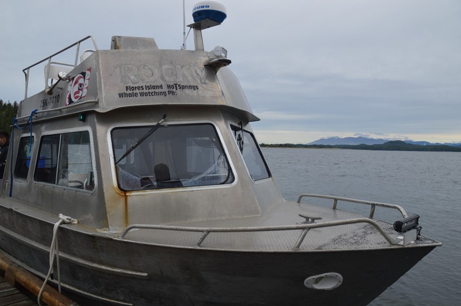
The Rocky Pass (Figure 1) is a water taxi that has an aluminum hull and an enclosed cabin. The cabin contains the conning station and a passenger seating area. The conning station, located on the forward starboard side of the cabin, has a seat for the operator, propulsion controls, a very high frequency (VHF) radiotelephone, and navigation equipment that includes a radar, a magnetic compass, and a GPS (global positioning system). The passenger seating area consists of rows of seats arranged on either side of a centre aisle. The cabin has front, side, and rear windows that provide the operator with a generally unobstructed view. The 2 outboard engines that propel the vessel are of 150 hp each and were fitted in 2021.
Personnel experience and certification
The operator of the Rocky Pass on the day of the occurrence had completed Small Vessel Operator Proficiency training and Small Non-Pleasure Vessel Basic Safety (Marine Emergency Duties A3) training in September 2008. He had been operating water taxis for approximately 20 years and was the principal operator of the Rocky Pass.
History of the voyage
On 25 January 2022 at 0905Footnote 1, the Rocky Pass departed Tofino, British Columbia (BC), en route to Ahousaht, BC, with the operator and 4 passengers on board. This was the operator’s 2nd trip of the day, having already made 1 trip from Ahousaht to Tofino. The wind was calm, and the swell was 0.1 m. There was dense fog, and visibility was reported to be less than 20 m.
Another water taxi had departed Tofino towards Ahousaht at roughly the same time as the Rocky Pass. There were also 2 other water taxis en route to Tofino.Footnote 2 The Rocky Pass operator took the usual route taken by water taxis that operate in the area. The route traverses Coomes Bank, which has numerous shallow areas and drying rocks.Footnote 3 The operator kept the Rocky Pass a few metres to the right of the usual track to leave room for opposing traffic. He navigated using the GPS while the vessel proceeded at approximately 22 knots.Footnote 4
As the vessel was transiting Coomes Bank, the GPS display froze and, as a result, the operator could no longer view the vessel’s actual position on the display. The operator was attempting to reset the GPS by using the zoom feature when he observed a rock directly in front of the vessel. The vessel hit the rock at approximately 0928 in position 49°13.96′ N, 125°59.79′ W.
The impact caused the vessel to come to an abrupt stop. The operator was thrown forward out of his seat and struck the front window but was subsequently able to stop the engines and transmit a Mayday call using the VHF radiotelephone with the assistance of one of the passengers. The operator sustained serious injuries, as did 3 of the passengers. The 4th passenger sustained minor injuries.
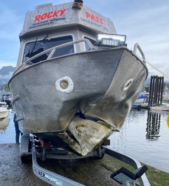
Nearby vessels, the Coastal Nations Coast Guard Auxiliary, and the Canadian Coast Guard responded to the Mayday call. First aid was administered to the operator and the 4 passengers, and they were transported to the hospital in Tofino. The Rocky Pass, which had a hole punctured in the bow from the impact with the rock (Figure 2), was towed to Tofino.
Voyage planning
Voyage planning provides vessel operators with an opportunity to assess the optimal route and speeds for a vessel’s passage based on the prevailing conditions. It includes consideration of weather, tides, vessel limitations, navigational hazards, and a contingency plan should the need arise. Under the Navigation Safety Regulations, 2020, “[t]he master of a vessel must, before the vessel embarks on a voyage, plan the voyage….Footnote 5”
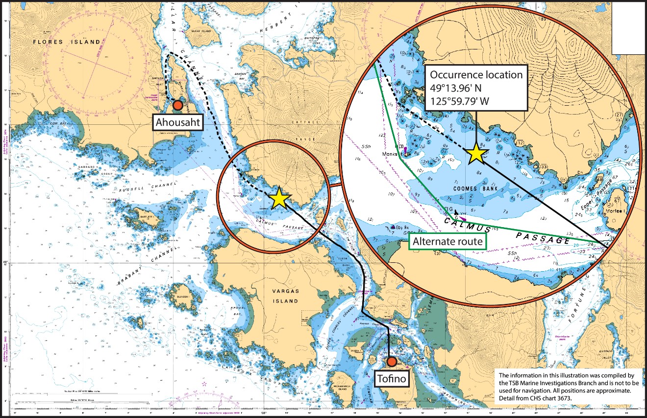
The typical route between Tofino and Ahousaht that water taxis use traverses Coomes Bank near the shoreline (Figure 3). This route is the most direct; however, in several areas, it requires vessel operators to navigate between or near navigational hazards, including drying rocks. Restricted visibility makes these navigational hazards less noticeable to operators. Without a radar, vessel operators must use their line of sight to monitor nearby vessel traffic and identify navigational hazards.
An alternative route exists along Calmus Passage, which is marked with navigation buoys (Figure 3). Along this route, the water is deeper and there are no drying rocks. It was not a practice for water taxis operating in the area to use this route on regular transits or when in restricted visibility.
Navigating in restricted visibility
Navigating in restricted visibility requires operators to make adaptations to regular navigation practices to ensure the safe passage of the vessel. For example, operators may need to proceed at slower speeds to ensure that the vessel can be safely stopped in time to prevent a collision.Footnote 6 In determining a safe speed, factors that must be taken into account include the visibility, the density of traffic, the manoeuvrability of the vessel, and the proximity to navigational hazards. As well, in restricted visibility without the benefit of visible landmarks, operators may need to use more than one navigational aid to cross-check the vessel’s position and have a back-up navigational aid in the event of equipment failure.
The Rocky Pass was transiting at 22 knots in an area with drying rocks and shallow water. Due to dense fog, the visibility at the time was less than 20 m. This speed in these conditions provided the operator with approximately 2 seconds to react to any navigational hazards. As well, the operator was relying on a single navigational aid, the GPS, to maintain a safe passage because the vessel’s radar was not in use during the voyage.Footnote 7 When the GPS display froze, the operator had no back-up navigational aid to provide position information.
Scheduling medical evacuations in remote communities
Ahousaht, like many other remote communities on the west coast of BC, relies on local community members with vessels to transfer patients to larger towns with medical facilities in the event of medical emergencies. Medical evacuations (MEDEVACs) from Ahousaht are initiated by local first responders who request, via VHF radiotelephone, vessel operators in Ahousaht to transport patients to Tofino, where emergency health services meet them. It is up to individual vessel operators to decide if they are able to conduct a MEDEVAC, and the first to respond typically completes it. Currently, there is no schedule for vessel operators in Ahousaht to indicate their availability to conduct MEDEVACs.
The operator of the Rocky Pass lives in Ahousaht and conducts MEDEVACs from the community. The night before the occurrence, there was a request for a MEDEVAC made over the VHF radiotelephone at approximately 2230. At that time, the operator of the Rocky Pass was preparing to go to sleep as he had scheduled trips in the morning. He waited approximately 20 minutes to see if someone else would respond to the call, and when no one else did, he responded. He departed Ahousaht en route to Tofino at approximately 2300 with the patient. Once in Tofino, the operator stayed at the wharf to see whether the patient would require a return transfer to Ahousaht. The operator slept in the boat for a while during this time before returning home at 0200 without the patient. The operator was awake again around 0615 for his previously scheduled trips and departed for the first voyage of the day at 0645.
Without a schedule to help identify which operators are available to conduct MEDEVACs on a given night, there is no predictability as to when operators may be asked to respond to MEDEVAC calls. This unpredictability makes it challenging for operators to prioritize their hours of rest and exposes them to the risk of fatigue. Although it is not known if fatigue was a factor in this occurrence, performance decrements associated with fatigueFootnote 8 are significant risk factors and predictors of occupational accidents and injuries,Footnote 9 including in the marine industry.Footnote 10
TSB Watchlist
The Watchlist identifies the key safety issues that need to be addressed to make Canada's transportation system even safer. Fatigue management is a Watchlist 2022 issue. As this occurrence demonstrates, there is a need to ensure that plans exist to mitigate the risk of vessel operators being exposed to fatigue.
Safety action taken
Transport Canada
On 26 April 2022, Transport Canada reached out to the Nuu-chah-nulth Tribal Council regarding occurrences in and near Tofino harbour in 2021 and early 2022. Transport Canada offered a follow-up discussion to share information about the current regulatory regime and better understand the Council’s perspectives about transportation safety in the Tofino area.
Safety messages
It is important that vessel operators, regardless of the size of their vessel, make a careful assessment of their intended route and safe speed by considering potential dangers to navigation; prevailing weather, particularly visibility; and other relevant factors.
Reliance on a single electronic navigational aid, especially in restricted visibility, can result in an accident. Mariners should continually cross-check their vessel’s position using all available means, including visual aids and radar.
This report concludes the Transportation Safety Board of Canada’s investigation into this occurrence. The Board authorized the release of this report on . It was officially released on .


