Pedestrian crossing protection in Sainte-Anne, Manitoba
Place du Centre
200 Promenade du Portage, 4th Floor
Gatineau QC K1A 1K8
26 October 2017
Safety advisory letter 624-20/17
Related occurrence: R17W0200
Letter addressed to the Mayor, Town of Sainte Anne
Subject: Rail Safety Advisory Letter – 624-20/17: Pedestrian crossing protection in Sainte-Anne, Manitoba
On 15 September 2017, at 1554 Central Daylight Time, Canadian National Railway (CN) freight train Q19851-11 (the train) was proceeding eastward at 38 mph when it struck an elementary school-age cyclist. At the time, the cyclist was travelling northward over a public pedestrian level grade crossing located at Mile 126.14 of the Sprague Subdivision (the crossing), in the town of Sainte-Anne, Manitoba (the town). The cyclist was transported to hospital, but succumbed to fatal injuries (TSB Occurrence No. R17W0200).
In the vicinity, the single main track is tangent. The crossing traverses the track at an angle of 147 degrees. The crossing is equipped with standard railway crossing signs (crossbucks), with an additional high speed train warning sign warning secured to each sign post. Rail traffic at this crossing averages 18 trains per day and the maximum permitted freight train speed is 60 mph.
The Canadian Rail Operating Rules (CROR) require the locomotive horn, bell and full power headlight to be activated when approaching the crossing, with the horn being sounded in accordance with CROR Rule 14(l). A review of the train's locomotive event recorder confirmed that the train horn was activated as the train approached the crossing, and that the train was operated in accordance with regulatory requirements.
Since the mid-1980s, a private road crossing was present at the location of the current pedestrian crossing. By November 2014, the private crossing was being regularly accessed by the public due to the expansion of the town on the south side of the tracks. Subsequently, the town applied to, and received approval from, the Canadian Transportation Agency (CTA) to install a public crossing at that location. As the authorized road authority, the town designated the crossing as a public pedestrian crossing and "pedestrian" was selected as the "design vehicle".
The construction of the public pedestrian level grade crossing was completed in September 2015 in accordance with the Transport Canada Grade Crossings Regulations (GCR) and accompanying Grade Crossings Standards (GCS). An S-shaped concrete sidewalk with an abrupt approach on both sides of the track was installed, and 1.2-metre (4-foot)-high chain link fence was installed along both sides of the sidewalk (Figure 1).
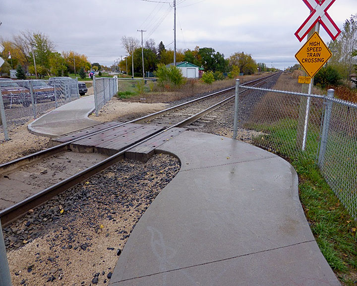
According to the GCS, for pedestrians standing 5 metres (16.4 feet) from the nearest rail, the available sightlineFootnote 1 for oncoming rail traffic travelling at up to 60 mph (96.5 km/h) should be approximately 273 metres (900 feet).
Following the accident, the Transportation Safety Board of Canada (TSB) examined the crossing and determined that the available sightline for oncoming rail traffic was unencumbered in both directions for pedestrians located 5 metres (16.4 feet) from the nearest rail. Therefore, the crossing met Transport Canada's applicable regulatory requirements for pedestrian use.
During the TSB's examination of the crossing site, it was observed that the crossing was also being used by cyclists as well as persons using assistive devices. Furthermore, it was reported that all-terrain vehicles and snowmobiles may also be regularly using the crossing.
According to the GCS, the sightline for cyclists and persons using assistive devices must be measured from a distance of about 15 metres (49.2 feet) from the nearest rail. The sightline measured along the rail for oncoming rail traffic travelling at 60 mph (96.5 km/h) should be the same as for pedestrians (273 metres or 900 feet).
However, when measured from a point located 15 metres (49.2 feet) from the south rail, the sightline for rail traffic approaching from the west was obstructed by vegetation and by two trackside bungalows. This limited the sightline to about 36 metres (120 feet). Consequently, for cyclists approaching the crossing from the south, the available sightline looking westward was insufficient.
The configuration of the crossing also created several unintended hazards:
- At the location where the 1.8-metre (6-foot)-wide concrete sidewalk meets the 2.4-metre (8-foot)-wide hardwood crossing ties, there is a 0.3 metre (1 foot) gap and a drop to the roadbed at each corner that creates a potential tripping hazard.
- The crossing configuration requires users of the crossing to focus attention downward when approaching the crossing in order to avoid the hazard.
- The abrupt approach to the track from the north and south provides minimal opportunity to observe the track in both directions prior to entering the crossing.
While the crossing met the regulatory requirements for the designated usage (pedestrians), there is nothing that precludes any party responsible for crossing safety from upgrading the crossing protection at any time. Options available that may enhance crossing safety at this location include, but are not limited to:
- The installation of maze barriers or bollard pipes that would require pedestrians to stop and cyclists to dismount prior to traversing the crossing.
- The realignment and widening of the crossing approach to 90 degrees at a sufficient distance from the rail in order to improve sightlines in both directions.
- The installation of automated flashing lights, bells and gates at the crossing.
Since the crossing usage is not restricted to pedestrians, it may be prudent for the parties involved to fully re-evaluate the crossing design using a more appropriate design vehicle that may include cyclists, persons using assistive devices as well as all-terrain vehicles and snowmobiles if necessary.
This information is provided for whatever follow-up action you deem appropriate.
Original signed by
Manuel Kotchounian
Acting Director
Investigation Operations, Rail/Pipeline
Cc.
- Transport Canada
- Canadian National Railway
- Town of Sainte-Anne, Manitoba
Background information
Occurrence No.
R17W0200
Contacts
Jerry Berriault, Regional Senior Investigator, Winnipeg Regional Office, Manitoba
Giorgio Celere, Regional Senior Investigator, Winnipeg Regional Office, Manitoba
Rob Johnston, Manager, Central Regional Operations - Rail, Head Office, Gatineau, Quebec