Collision with trees after takeoff
Piper PA-28-140, C-GVZP
Sechelt Aerodrome, British Columbia
The Transportation Safety Board of Canada (TSB) investigated this occurrence for the purpose of advancing transportation safety. It is not the function of the Board to assign fault or determine civil or criminal liability. This report is not created for use in the context of legal, disciplinary or other proceedings. See Ownership and use of content. Masculine pronouns and position titles may be used to signify all genders to comply with the Canadian Transportation Accident Investigation and Safety Board Act (S.C. 1989, c. 3).
History of the flight
Just after 1400Footnote 1 on 05 July 2018, the Piper PA-28-140 aircraft (registration C-GVZP, serial number 28-25340) took off from Runway 29 at Sechelt Aerodrome (CAP3), British Columbia, with the pilot and 3 of his family members—1 adult and 2 children—on board for the first of 2 local sightseeing flights about 8 nautical miles (nm) to the northwest. At that time, the airport's windsocks indicated that the prevailing wind was from the west.
After a 20-minute flight, the aircraft returned and landed on Runway 29; the windsock at the east end of the runway indicated a light wind from the east, giving the aircraft a tailwind.
The pilot took a short break between flights due to the high temperature in the aircraft cabin. Then, 3 other members of his family—1 adult, 1 teenager, and 1 child—boarded the aircraft for a flight similar to the previous one. While the passengers were boarding the aircraft, the windsock at the east end of the runway indicated that the wind was from the west, as it had been for the previous takeoff. However, a few minutes later, while the aircraft was taxiing to Runway 29, the wind changed to a light wind from the east, and remained in that direction while the aircraft took off. The wind was also reported to have become gusty around this time.
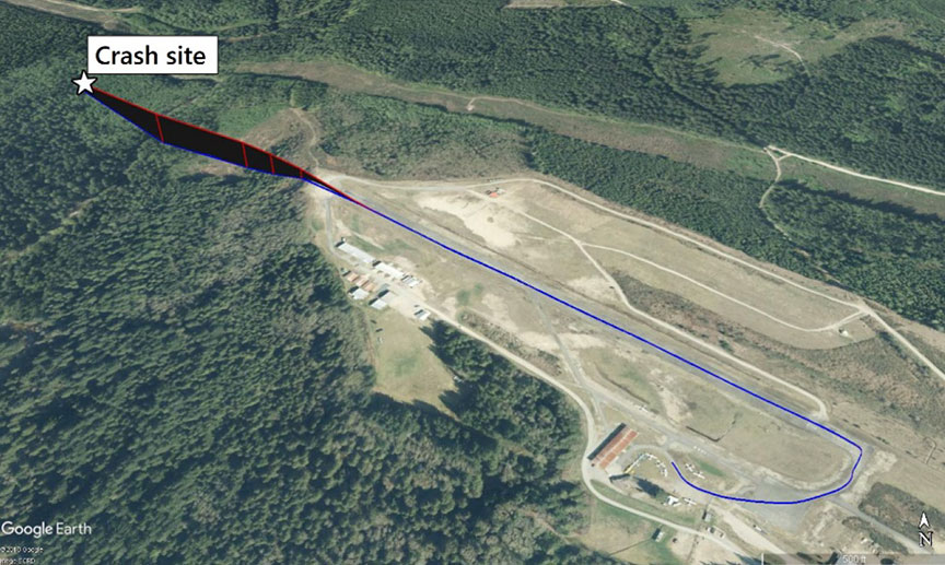
At about 1444, the aircraft took off from Runway 29 with the flaps in the retracted (up) position. It remained on the runway for almost three quarters of the runway's length before lifting off. The aircraft climbed for several seconds, reaching a maximum height of about 100 feet above runway elevation and wobbledFootnote 2 several times during the flight. The aircraft maintained a nose-up attitude and slowly decelerated as it crossed the Chapman Creek ravine. It was airborne for less than 30 seconds before it collided with trees and crashed on the far side of the ravine, about 0.35 nm from the departure end of the runway (Figure 1).
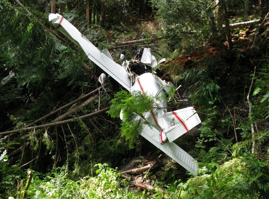
The aircraft was destroyed (Figure 2). The pilot was fatally injured. The 3 passengers received minor injuries and were able to exit the aircraft and walk to nearby houses. The emergency locator transmitter did not activate during the crash. There was no post-impact fire.
Aerodrome
CAP3 is a registered aerodrome operated by the District of Sechelt. Aerodromes are governed by Canadian Aviation Regulations Subpart 301 and are not required to meet the requirements of certified airports under Canadian Aviation Regulations Subpart 302. CAP3 has a single asphalt runway (Runway 11/29), which is 2400 feet long and has windsocks situated at both ends. Runway 29 slopes uphill at an average of about 1% (0.6°). The aerodrome elevation is 300 feet above sea level (ASL).
The edition of the Canada Flight Supplement (CFS)Footnote 3 that was current at the time of the accident contained a caution section for CAP3 that stated:
Strongly recommended that only pilots familiar with [local] terrain should use this [aerodrome] at [night]. [Runway] 11: trees to 100 [above ground level] on [approach] & within 300 [feet north] of Extended centreline. [Unlighted] terrain lies to [north] of [airport] & rises steeply in dep[arture] area [Runway] 29. Ditch 3 [feet] deep parallels [north] side of [runway approximately] 35 [feet from] [runway] edge.Footnote 4
The CFS does not note that Runway 29 is sloped slightly uphill, and there are no warning signs at the aerodrome. Because CAP3 is a registered aerodrome, rather than a certified airport, the CFS is not requiredFootnote 5Footnote 6 to contain runway slope information. However, runway slope and other information can be published in the CFS if the aerodrome operator provides the information.
Pilot
Records indicate that the pilot was certified and qualified for the flight in accordance with existing regulations. The pilot held a private pilot licence – aeroplane with a valid Category 3 medical certificate. He had accumulated a total of 1219 hours flight time, of which about 63 were on the occurrence aircraft. There were no indications that fatigue was a factor in this occurrence.
Weather
The accident occurred during daylight hours, and visibility was unlimited. Environment and Climate Change Canada owns and operates a weather-recording station, Sechelt AUT (ID: VOU), located about 400 feet southwest of the threshold of Runway 29. The station is automated and records basic meteorological parameters on the hour.
Information for 1400, near the time of the first flight, indicated the following:
- temperature: 22.5 °C
- dew point: 14.5 °C
- wind: 10 km/h from 280° true (T)
- station pressure: 29.69 inHg
- density altitude 1378 feet above sea level
Information for 1500, about 16 minutes after the accident, indicated the following:
- temperature: 23.7 °C
- dew point: 13.9 °C
- wind: 10 km/h from 290°T
- station pressure: 29.68 inHg
- density altitude 1507 feet above sea level
Based on the weather data for 1500, the density altitude was calculated to have been about 1500 feet ASL. A higher density altitude results in decreased engine power, decreased (propeller) thrust, and decreased (wing) lift.
In the half hour before the accident flight departed, the airport's windsocks indicated that the wind had become variable in speed and direction, with the windsocks at times turning through 360°.
Local pilots report that turbulence and downdrafts are common over Chapman Creek, which is immediately off the departure end of Runway 29. This information is not noted in the CFS, nor is it required to be.
A pilot who had landed on Runway 11 at CAP3 an hour before the accident experienced turbulence and downdrafts over Chapman Creek that were so severe that he radioed to warn another aircraft that was inbound for landing.
Aircraft
The aircraft was a Piper PA28-140, commonly known as a Cherokee 140. It was manufactured by the Piper Aircraft Corporation in 1969 and was registered in the United States as N8096N. In September 2016, the aircraft was purchased by the occurrence pilot, imported to Canada, and re-registered as C-GVZP. At the time of the accident, the aircraft had accumulated about 3109 hours total time. Records indicate that the aircraft was certified, equipped, and maintained in accordance with existing regulations and approved procedures.
The aircraft was equipped at manufacture with a Lycoming O-320-E2A engine (serial number L-24534-27A) producing 150 hp. In January 2017, the engine was modified in accordance with supplemental type certificateFootnote 7 SE8987SW-D to produce 160 hp. The supplemental type certificate does not claim to provide any increase in aircraft performance. Following the accident, the engine was transported to an approved facility for testing and inspection. All damage and defects noted were attributable to the engine's and propeller's collision with trees, and the engine was run satisfactorily on a test stand.
TSB calculations indicate that the occurrence aircraft was at or near maximum gross weight at the time of the accident and that its centre of gravity was inside of the allowable envelope.
Performance
Section III of the Cherokee 140 B PA-28-140 Owner's Handbook indicates that, at gross weight (2150 pounds in the “normal” category) and at sea level, the stall speed with power off and flaps up is 64 mph.Footnote 8 Section III also indicates that best angle of climb is obtained at 74 mph.Footnote 9
According to the performance charts in Section IV of the Owner's Handbook, the minimum take-off distance (ground roll) for an aircraft at 2150 pounds gross weight and at 1500 feet ASL density altitude would be about 1000 feetFootnote 10 and the maximum rate of climb would be about 600 fpm.Footnote 11 The Owner's Handbook does not indicate what effect, if any, taking off on a runway with a 1% uphill slope would have.
Global positioning system data shows differences in aircraft performance on the first flight compared to the accident flight. Both flights became airborne at about 73 mph (ground speedFootnote 12), but on the accident flight, the ground run (1700 feet) to reach that speed was longer than on the previous flight (1300 feet). Both ground runs were longer than the minimum indicated in the Owner's Handbook (1000 feet) for the density altitude. On the earlier flight, the aircraft continued to accelerate while climbing after takeoff. However, on the accident flight, the highest speed the aircraft reached was at liftoff. After this point, the ground speed steadily decreased to 59 mph—even though the aircraft was descending for about the last 15 seconds of the flight—and the aircraft collided with trees.
Factors present in this accident
The TSB has investigated numerous occurrences in which aircraft performance was insufficient for the conditions.
In this accident, the aircraft's performance decreased, resulting in its inability to climb above the terrain. This decrease in performance was not the result of a single factor:
- The aircraft took off with a tailwind, which increased the required take-off distance.
- The take-off runway (Runway 29) slopes uphill at 1% (0.6°). Uphill takeoffs decrease take-off performance. Runway slope information is not included in the CFS entry for CAP3, nor is the effect of runway slope included in the PA-28 performance charts.
- The aircraft was at or near maximum gross weight. Increased aircraft weight decreases take-off and climb performance.
- The density altitude around the time of the accident was about 1500 feet ASL, primarily because of increasing air temperature. Higher density altitudes decrease aircraft performance.
- The aircraft may have encountered turbulence and downdrafts over Chapman Creek. This may have further decreased the aircraft's climb performance. Turbulence and downdrafts over Chapman Creek are phenomena known to local pilots and had been reported by another pilot earlier in the day. The “Caution” section of the CFS entry for CAP3 does not mention turbulence and downdrafts over Chapman Creek, and there are no warning signs at the aerodrome.
Safety message
Pilots must remain vigilant to changes in the factors that can affect the performance of their aircraft.
This concludes the TSB's limited-scope investigation into this occurrence. The Board authorized the release of this investigation report on . It was officially released on .

