Runway excursion
Buffalo Airways Ltd.
Beechcraft King Air A100, C-FCBZ
Kugaaruk Airport, Nunavut
The Transportation Safety Board of Canada (TSB) investigated this occurrence for the purpose of advancing transportation safety. It is not the function of the Board to assign fault or determine civil or criminal liability. This report is not created for use in the context of legal, disciplinary or other proceedings. See Ownership and use of content. Masculine pronouns and position titles may be used to signify all genders to comply with the Canadian Transportation Accident Investigation and Safety Board Act (S.C. 1989, c. 3).
Summary
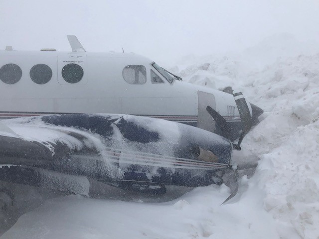
On 28 April 2020, the Buffalo Airways Ltd. Beechcraft King Air A100 aircraft (registration C-FCBZ, serial number B-116) was conducting charter flight BFL666, under instrument flight rules, from Cambridge Bay Airport, Nunavut, to Kugaaruk Airport, Nunavut, with 2 flight crew members and freight on board. At 1350 Mountain Daylight Time, during the hours of daylight, the aircraft landed at Kugaaruk Airport on Runway 23. Immediately after touchdown the aircraft veered to the right and departed from the runway surface. The aircraft came to rest after colliding with a snowbank on the northwest side of the runway. The crew, who were not injured, egressed the aircraft via the main cabin door. There was no fire, but the aircraft sustained substantial damage. The 406 MHz emergency locator transmitter did not activate.
1.0 Factual information
1.1 History of the flight
1.1.1 Background
On 28 April 2020, the Beechcraft King Air A100 aircraft (registration C-FCBZ, serial number B-116), operated by Buffalo Airways Ltd. (Buffalo Airways) as flight BFL666, was scheduled to depart Yellowknife Airport (CYZF), Northwest Territories, fly to Cambridge Bay Airport (CYCB), Nunavut, pick up freight there, and then continue on to Kugaaruk Airport (CYBB), Nunavut.
At approximately 0800, Footnote 1 the captain arrived at the Buffalo Airways hangar at CYZF to begin preparations for the flight. The first officer arrived at the hangar at 0900. The captain arranged for the aircraft to be fuelled while the first officer filed an instrument flight rules (IFR) flight plan from CYZF to CYCB. The aircraft departed CYZF at 0952 for its flight to CYCB, with the captain occupying the left seat and the first officer occupying the right seat.
The aircraft landed at CYCB at 1149. The aircraft was refuelled and freight, consisting of boxed cans of camp fuel (naphtha), was loaded into the cabin and belly pod. The first officer checked the weather and filed an IFR flight plan for the flight from CYCB to CYBB with Gjoa Haven Airport (CYHK), Nunavut, as the planned alternate airport.
1.1.2 Occurrence flight
At 1216, the aircraft departed CYCB for CYBB, a flight that would last approximately 1 hour and 30 minutes. The first officer was the pilot flying. As the aircraft passed by CYHK, the flight crew noted that, based on the weather reported by the airport’s automated weather observation system, CYHK was still acceptable to use as an alternate airport. At 1319, when the flight was about 80 nautical miles from CYBB at flight level 210, Footnote 2 the flight crew called the CYBB community aerodrome radio station. The flight crew received the runway surface condition report and were informed that the winds were from 200° true (T), at 24 knots gusting to 33 knots. At 1320, the community aerodrome radio station operator called the flight crew and relayed the CYBB 1300 weather observation, reporting that the horizontal visibility was ¼ statute mile (SM) in light snow and blowing snow and that the vertical visibility was 400 feet. The flight crew noted that the visibility had decreased since their departure from CYCB but continued the approach. The reported wind would result in a 12-to 16-knot crosswind component from the left on Runway 23. The captain took control at 1327, at the start of the descent, and descent checks were carried out.
The captain transferred control back to the first officer at the initial approach waypoint, DATLA, and briefed for a pilot-monitored area navigation (RNAV) approach to Runway 23 (Appendix A). From the intermediate approach waypoint, ONDEM, through the final approach waypoint, TEVID, to the missed approach waypoint, VOBUB, the approach is flown on a track of 244°T, which is offset 15° from the runway heading of 229°T (Appendix A). When the runway is acquired visually at or before the minimum descent altitude (MDA), a left turn is required to align the aircraft with the runway heading.
During the descent the flight crew activated the runway lights and the precision approach path indicator (PAPI) system via the aircraft radio control of airport lighting system (ARCAL). The captain set the flaps to the approach setting (40%), and the first officer flew the descent. When the captain then confirmed visual contact with the runway, snow was blowing across it at an angle from left to right. The runway itself was apparent as a black shape within the blowing snow; however, the runway lighting and PAPI were not observed. The captain set the flaps to the land setting (100%) and then, as part of the pilot-monitored approach procedure, assumed control of the aircraft as the pilot flying. The first officer looked up from the instruments and observed, through the blowing snow, the runway as well as the community aerodrome radio station and airport apron ahead and off to the left.
The aircraft crossed the runway threshold at 100 knots indicated airspeed. As the captain flared the aircraft, the first officer warned the captain of snowbanks off to the right side of the runway.
At 1350, when the right main landing gear touched down, the aircraft veered to the right and departed the runway surface. The right wing contacted snowbanks and the aircraft turned approximately 90° to the right before colliding nose first with a high snowbank. Both crew members, who were not injured, exited through the cabin door.
The aircraft was substantially damaged; however, the freight remained secure. The 406 MHz emergency locator transmitter (ELT) did not activate and there was no fire. First responders had difficulty travelling from the hamlet to the airport due to the blowing snow.
1.2 Injuries to persons
There were no injuries to the 2 flight crew members.
1.3 Damage to aircraft
The aircraft’s fuselage, nose, engines, propellers, nacelles, flaps, wing centre section, and right wing spar were damaged (Figure 1). The right wing was bent up and aft. The nose landing gear leg collapsed aft and to the right. The right outboard main-wheel tire had detached when the wheel rim broke; it was found close to the aircraft. The fracture surfaces of the broken wheel indicated that the wheel rim had broken in overload during the runway excursion.
1.4 Other damage
Not applicable.
1.5 Personnel information
| Captain | First officer | |
|---|---|---|
| Pilot licence | Airline transport pilot licence | Commercial pilot licence |
| Medical expiry date | 01 May 2020 | 01 November 2020 |
| Pilot proficiency check or pilot competency check expiry date | 01 November 2020 | 01 April 2021 |
| Total flying hours | Approximately 13 500 | Approximately 1600 |
| Flight hours on type | Approximately 800 | Approximately 1100 |
| Flight hours in the 7 days before the occurrence | 15.4 | 3.9 |
| Flight hours in the 30 days before the occurrence | 27.7 | 18.3 |
| Flight hours in the 90 days before the occurrence | 229.2 | 78.5 |
| Flight hours on type in the 90 days before the occurrence | 18.7 | 78.5 |
| Hours on duty before the occurrence | 6 | 5 |
| Hours or days off duty before the work period | 15 hours | 12 days |
The flight crew were certified and qualified for the flight in accordance with existing regulations.
The captain, who was the designated pilot-in-command (PIC) for the occurrence flight, joined Buffalo Airways in 2006 and has flown all the aircraft types in the operator’s fleet. The captain had completed a pilot proficiency check on the Beechcraft King Air A100 on 04 October 2019.
The first officer flew the Beechcraft King Air A100 exclusively since joining Buffalo Airways in 2017, and had completed a pilot competency check on 28 March 2020.
1.6 Aircraft information
The Beechcraft King Air A100 is a pressurized, twin-engine, turboprop, fixed-wing aircraft manufactured by Beech Aircraft Corporation that can accommodate up to 9 passengers in the standard seating configuration. The wingspan of the King Air A100 is 45 feet 9 inches. The span of each wing from its respective outboard main wheel is approximately 15 feet. For takeoffs and landings, the aircraft has a maximum demonstrated crosswind of 25 knots.Footnote 3
The aircraft was equipped with an autopilot, a Garmin GNS 530W GPS (global positioning system)/navigation/communication unit, a Garmin 430W GPS/navigation/communication unit, a Latitude S200-021 satellite tracking system, and an Artex ELT Model ME406.
Modifications to the occurrence aircraft included installation of upgraded propellers in accordance with a Supplemental Type Certificate.Footnote 4 Other modifications increased the maximum gross take-off weight to 12 008 pounds, whereas the maximum allowable landing weight remained at 11 210 pounds. The aircraft was equipped with a belly pod to facilitate carriage of baggage and/or freight. According to flight documents, the aircraft’s weight and centre of gravity during the occurrence flight were within prescribed limits.
Records indicate that there were no outstanding defects at the time of the occurrence. There was no indication that a component or system malfunction played a role in this occurrence.
| Manufacturer | Beech Aircraft Corporation |
|---|---|
| Type, model, and registration | King Air A100, C-FCBZ |
| Year of manufacture | 1972 |
| Serial number | B-116 |
| Certificate of airworthiness issue date | 23 May 2010 |
| Total airframe time | 13 028.8 hours |
| Engine type (number of engines) | Pratt & Whitney Canada PT6A-28 (2) |
| Propeller type (number of propellers) | Hartzell Propeller Inc. HC-D4N-3C (2) |
| Maximum allowable takeoff weight - lb (kg) | 12 008 lb (5446.8 kg) |
| Recommended fuel type(s) | Jet A, Jet A-1, Jet B |
| Fuel type used | Jet A |
1.7 Meteorological information
In the early morning hours of 28 April 2020, winter-storm conditions were present at CYBB, and wind speeds began to increase at approximately 0500. Light snow, combined with blowing snow, produced poor visibility that made travel difficult within the hamlet and at the airport. These conditions persisted until after the occurrence.
When the first officer checked the weather during the stop at CYCB, the CYBB aerodrome forecast issued at 1146 was the following:
- from 1100 to 1700, winds from 200°T at 20 knots, gusting to 30 knots, visibility 1 SM in light snow and blowing snow, overcast ceiling at 2000 feet; and,
- temporarily from 1100 to 1700, visibility 3 SM in blowing snow, overcast ceiling at 2500 feet.
The 1300 CYBB aerodrome routine meteorological report (METAR) provided to the flight crew at 1320 indicated the following:
- winds from 200°T at 24 knots, gusting to 33 knots
- visibility ¼ SM in light snow and blowing snow
- vertical visibility 400 feet
Approximately 10 minutes after the occurrence, the 1400 METAR indicated the following:
- winds from 200°T at 24 knots, gusting to 32 knots
- visibility ¼ SM in light snow and blowing snow
- vertical visibility 400 feet
1.8 Aids to navigation
The crew were using the approach chart for the RNAV (GNSS) [global navigation satellite system] approach to Runway 23 at CYBB (Appendix A) published in the Canada Air Pilot (CAP), CAP 1: Yukon, Northwest Territories and Nunavut.
1.9 Communications
Not applicable.
1.10 Aerodrome information
CYBB is owned by the Government of Nunavut and is operated by the Nunavut Airports Division of the Department of Economic Development and Transportation. The airport, along with CYCB, CYHK, Kugluktuk Airport (CYCO), and Taloyoak Airport (CYYH), is in the Kitikmeot Region of the Nunavut Airports Division.
There is no air traffic control tower at CYBB. Weather and aircraft advisory services are provided by the CYBB community aerodrome radio station on the 122.1 MHz mandatory frequency. The community aerodrome radio station is located approximately 1/5 SM from the threshold of Runway 23.
The Nunavut Airports Division maintains a Transport Canada (TC)-approved safety management system (SMS).
1.10.1 Runway 05/23
The runway at CYBB (Runway 05/23) is a 5000-foot-long, 100-foot-wide gravel runway. The runway strip is graded to a width of 151 feet. Runway 23 is oriented to 229°T, and the threshold is 20 feet above sea level. Runway 23 is certified with an aerodrome operating visibility of ½ SM.
A runway surface condition report was issued on 28 April 2020 at 0808 that described the runway conditions as 70% bare and dry, and 30% dry snow over a trace of compacted snow.
1.10.2 Runway lighting
Runway 05/23 is equipped with runway threshold lights and runway end lights, which appear green and red respectively. The runway edge lights are white and pole-mounted 27 inches (70 cm) above the surface (this is higher than the standard 35 cm).Footnote 5 The edge lights are 55 feet from the runway centreline and 5 feet outside the runway edge.
1.10.2.1 Aircraft radio control of aerodrome lighting
The airport lighting is controlled by an ARCAL type K system operating on 122.1 MHz. Keying a microphone 7 times initially will turn the lighting on at maximum intensity for 15 minutes. The lighting intensity can be adjusted by keying the microphone 7, 5, or 3 times within 5 seconds to select the high, medium, or low level, respectively.
1.10.2.2 Precision approach path indicator
Runway 05/23 is served by type P1 PAPIs, which are calibrated for aircraft with an eye-to-wheel height of up to 10 feet. The PAPI was activated automatically when the flight crew turned on the runway lights with the ARCAL system.
1.10.3 Winter maintenance
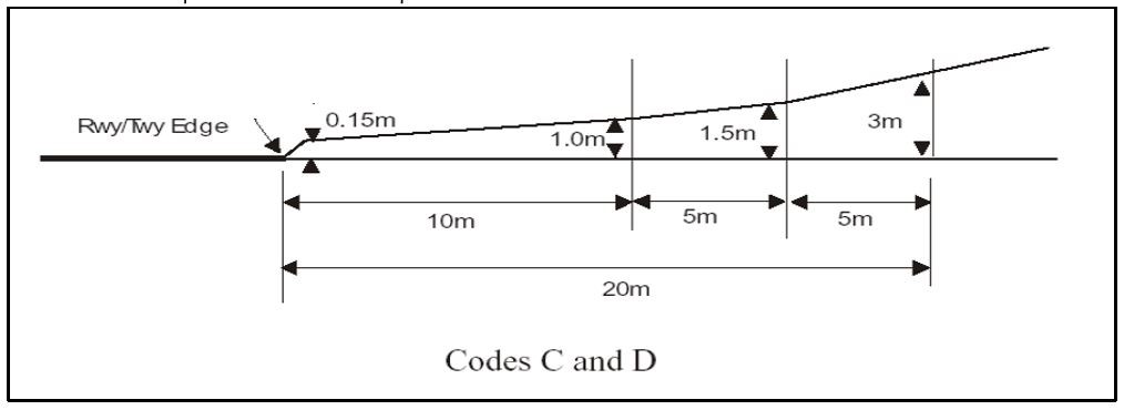
The Nunavut Airports Division’s Winter Maintenance PlanFootnote 6 is common to all airports operated by the Division. The Winter Maintenance Plan was prepared using the TC Advisory Circular 302-013Footnote 7 as a guide. All Nunavut airports, with the exception of Grise Fiord Airport (CYGZ) and Kimmirut Airport (CYLC), are listed as code C and D airports.Footnote 8 The code refers to either the maximum wing span or the outer main gear wheel span of aircraft that may operate from the airport.Footnote 9 The Winter Maintenance Plan contains an International Civil Aviation Organization (ICAO) diagram indicating that the maximum snow depth can be 0.15 m near the runway edge, increasing to 1.0 m at a 10.0 m distance from the runway edge (Figure 2).
Airport snow removal during blizzards is to be curtailed when the airport maintainer determines that travel to the airport is too hazardous, as was the case on the day of the occurrence. TC’s Advisory Circular 302-013 recommends that, if successive hours or days of snowfall cause priority areas to exceed the snowbank slope limitations, the airport operator should indicate this by issuing a NOTAM.Footnote 10 The Winter Maintenance Plan does not contain this guidance, nor was a NOTAM issued.
The aircraft movement surface condition report is issued via NOTAM to alert pilots to changing conditions that could affect braking performance. The Winter Maintenance Plan calls for an aircraft movement surface condition report to be completed at least daily and as required to identify significant changes in the runway surface conditions.Footnote 11 There is no mention of the conditions under which a runway should be closed, or of who has the authority to do so.
Since the beginning of February 2020, the CYBB daily reports, that were submitted to the airport operator by the airport maintainers, referred to snow buildup near the runway and the inability to move it with the grader. A number of daily report entries mentioned that the operator was made aware of unserviceable equipment and the need for parts required for repairs. An entry on 27 March 2020 indicated that the snowblower had been out of commission for 2 months and also mentioned problems with the loader. In addition, on the same day, an SMS report was generated by an airport maintainer and submitted to the airport operator, regarding snowbanks that were building up close to the runway.
On 27 April 2020, the day before the occurrence, a loader was rented from the hamlet for a period of 4 hours. The removal of snowbanks from the area outside the runway lights began; however, it could not be completed within the 4 hours and resulted in even higher snowbanks. A CYBB daily report entry made on 30 April 2020, 2 days after the occurrence, indicated that the snowbanks were within 5 feet of the runway lights and measured 8 feet high.
The SMS report generated on 27 March 2020 was closed on 30 April 2020, 2 days after the occurrence, after equipment had been rented from the hamlet to facilitate snow clearing.
The airport is maintained by a 3rd party on a contractual basis. The contractor employs local workers as airport maintainers. The following snow removal equipment is owned by the Nunavut Airports Division but is operated and maintained by the contractor:
- 1x Caterpillar 938 Loader
- 1x Larue D50 Snowblower
- 1x Caterpillar 140M2 Grader
The airport maintainers also have access to additional equipment owned by the hamlet on an as-required rental basis. The hamlet’s loader was rented 4 times in March and April 2020. The hamlet’s bulldozer was rented 4 times in April 2020.
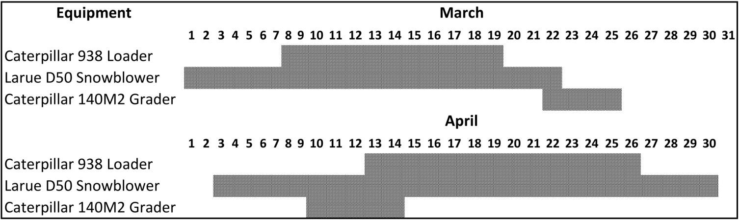
Although the hamlet’s loader and bulldozer were used to remove snow from the operating areas of the airport, the airport’s snowblower was only available from 23 March 2020 to 02 April 2020. For the remainder of March and April the snowblower was out of service (Figure 3). A daily report entry on 02 April 2020 mentions that the COVID-19 travel restrictions had “put everything on hold.” The investigation did not determine to what degree this affected the contractor’s ability to maintain the airport equipment.
The snowblower was needed to allow the maintainers to move the snow away from the runway, taxiway, and apron and spread it out over a wider area.
1.11 Flight recorders
The aircraft was not equipped with a flight data recorder or a cockpit voice recorder, and neither was required by regulation. However, in this occurrence, the lack of recorded data did not significantly impede the investigation.
1.12 Wreckage and impact information
Due to the COVID-19 pandemic travel restrictions that were in place at the time, TSB investigators did not travel to the site of the occurrence. As a result, a significant portion of the information necessary for the investigation was gathered from alternate sources.
During the runway excursion, the aircraft turned almost 90° to the right when the right wing contacted a snowbank. The aircraft came to rest nose first against a high snowbank on the northwest side of Runway 23, approximately 1900 feet past the threshold.
At the time of the occurrence, the snowbank height and proximity to the runway edge lights was in excess of TC guidanceFootnote 12 in some areas along the length of the runway. The aircraft came to rest in an opened up area where the snowbanks were further from the edge lights than they were along the rest of the runway, but were noted to be above head height. Drifting snow that accumulated during the day appeared to have built up around, and as high as, the runway edge lights.
There was no noted damage to the runway lighting or other airport infrastructure and no spillage from either the freight or the aircraft’s fuel or oil systems.
A photo of the runway was taken the day following the occurrence, after snow clearing had begun (Figure 4). Due to the presence of snowbanks along the runway, the only portion of the aircraft that is visible in the photo is the vertical stabilizer. The photo also shows that the snow accumulation along the runway is almost as high as runway edge lights, which are 27 inches high.
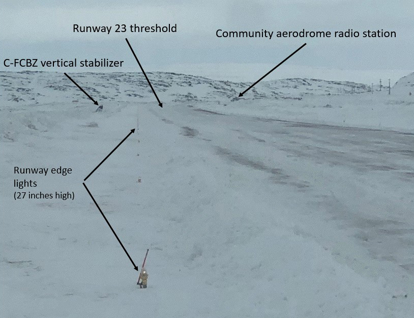
The TSB Engineering Laboratory attempted to analyze the photo to determine the height of the snowbanks along the runway and their proximity to the runway lights. However, there were insufficient data and geographic references to derive accurate measurements.
1.13 Medical and pathological information
There were no indications that the flight crew’s performance was affected by fatigue or other medical, pathological, and physiological factors.
1.14 Fire
Not applicable.
1.15 Survival aspects
1.15.1 Safety belts
The aircraft cockpit and cabin remained intact and provided a survivable space. Both pilots were wearing lap belts and each cockpit seat was equipped with a shoulder harness, but only the captain wore it. The first officer chose not to use the shoulder harness because the layout of the occurrence aircraft made it difficult to reach certain cockpit controls while wearing it.
The use of a 3- or 4-point restraint system (consisting of a lap belt and shoulder harness) ensures a more equal distribution of the impact forces and may reduce the risk of severe injuries to the upper body and head.
The TSB has investigated many accidentsFootnote 13 involving aircraft that were equipped with detachable shoulder harnesses, in which the TSB determined that the harnesses were not worn at the time of the accident.
Following an accident involving an Airbus Helicopters AS 350 B2 helicopter on 14 December 2017 in Tweed, Ontario,Footnote 14 the TSB investigation determined that the passengers’ shoulder harnesses were not used with the lap belts. Based on the definition of “safety belt” in the Canadian Aviation Regulations (CARs), the company had considered that it would be in compliance with the regulations if the occupants wore either the lap belt alone, or the lap belt combined with the shoulder harness. Therefore, the Board recommended that
the Department of Transport amend the Canadian Aviation Regulations to remove any ambiguity associated with the definition of “safety belt.”
TSB Recommendation A19-01
Since that time, the TSB has followed up with TC on action being taken to address this recommendation. When the present report was published, TC’s response had been received in December 2020. The Board’s March 2021 assessment of this response is available on the TSB website.Footnote 15
1.15.2 Emergency locator transmitter
The Artex Model ME406 ELT (part number 453-6603) is able to transmit on 121.5 MHz and 406 MHz and will activate automatically when longitudinal deceleration forces exceed 2.3g. The initial veer to the right and subsequent impact with the snowbank did not generate sufficient force to activate the ELT, nor did the flight crew activate it manually.
1.16 Tests and research
The TSB completed the following laboratory report in support of this investigation:
- LP099/2020 – Photo analysis
1.17 Organizational and management information
1.17.1 General
Buffalo Airways Ltd. has been in operation since 1970 and operates under the authority of a TC-issued air operator certificate to conduct work under CARs Part VII, subparts 702 (Aerial Work), 703 (Air Taxi Operations), and 705 (Airline Operations). The occurrence flight was operating under CARs subpart 703 on a charter flight.
1.17.2 Company operations manual
The Buffalo Airways company operations manual (COM) is the guiding document for flight operations conducted by the company. The COM states that IFR approaches in instrument meteorological conditions must be conducted in accordance with the procedures published in the CAP.Footnote 16
Further guidance is also provided in section 5.12 of the COM with regards to approach bans (see section 1.18.2 Operational approach and landing minima of the report). The COM states that Buffalo Airways does not hold any flight authorization for lower than general approach requirements (Operations Specification 019), as outlined in the CAP, General Pages (CAP GEN). The COM also states that “Ground visibility is NOT limiting North of the 60th parallel.”Footnote 17 The COM makes no mention of aerodrome operating visibility requirements.
1.18 Additional information
1.18.1 Visibility published in the Canada Air Pilot
When the approach chart used by the occurrence flight crew was designed, the published advisory visibility for the RNAV (GNSS) Footnote 18 approach to Runway 23 (True) was 1¾ SM. This was based on an aircraft’s distance from the runway threshold when it reaches the MDA while flying the optimal descent slope of 3°. In all likelihood, this visibility should enable pilots to see the visual references required to proceed with the landing (see section 1.18.3 Aerodrome operating visibility of the report). However, in Canada, these published landing visibilities are provided for information purposes only and, as stated the CAP GEN,
are not limiting and are intended to be used by pilots to judge the probability of a successful landing when compared against available visibility reports at the aerodrome to which an instrument approach is being carried out. Footnote 19
1.18.2 Operational approach and landing minima
The CAP GEN states that
CAR 602 specifies that landings are governed by published DH [decision height]/MDA. Pilots of aircraft on instrument approaches are prohibited from continuing the descent below DH, or descending below MDA, as applicable, unless the required visual reference is established and maintained in order to complete a safe landing. When the required visual reference is not established or maintained, a missed approach must be initiated. Footnote 20
ICAO standards stipulate that an instrument approach shall not be continued unless the reported visibility is at or above the specified minima. Footnote 21 These minima are published on approach charts based on the approach type and lighting.
Various civil aviation authorities throughout the world (such as the U. S. Federal Aviation Administration [FAA] and the European Union Aviation Safety Agency [EASA]), specify that minimum visibility is that which is specified and published for the approach.
However, in Canada, minimum visibility is defined as a calculation that applies to all approaches but varies depending on the type of operation. This calculation, known as the approach ban, is applied to the published visibility (which is not limiting, but rather provided for information purposes only).
1.18.2.1 Approach ban
The approach ban’s minimum visibility calculations are:
- ¾ of the published visibility for commercial operators
- ½ of the published visibility for commercial operators who have Operations Specification 019 regarding reduced visibility
- ¼ SM for private operators, regardless of the approach being executed
The occurrence flight was conducted under commercial operations without Operations Specification 019. The minimum visibility calculation of ¾ of the 1¾ SM published visibility for the RNAV (GNSS) approach to Runway 23 (True) at CYBB would be 1½ SM. The CAP GEN lists the hierarchy that dictates which visibility report will take precedence in the calculation of the approach ban:
An RVR [runway visual range] report takes precedence over a runway visibility report or a ground visibility report, and a runway visibility report takes precedence over a ground visibility report. Footnote 22
However, the CAP GEN also states the following:
Ground visibility will only impose an approach ban at aerodromes south of 60°N latitude. Footnote 23
Due to the fact that CYBB provides neither RVR nor runway visibility reports, and that the aerodrome is located north of 60°N latitude, there is no approach ban for any approach at CYBB, regardless of the reported ground visibility.
1.18.3 Aerodrome operating visibility
When deciding whether to conduct a flight, the PIC of the aircraft must be satisfied that the conditions at the destination aerodrome are suitable for the intended operation. The PIC must ensure that the expected visibility falls within the aerodrome’s certified operating visibility (Appendix B). When an aerodrome is certified for an operating visibility of less than ½ SM, RVR 2600, the limit is published in the runway section of the Canada Flight Supplement (CFS) and on the aerodrome chart published in the CAP. If an aerodrome’s operating visibility limit is not published in the CFS, as is the case for CYBB, it means that operations are not authorized when visibility is less than ½ SM.
At aerodromes without an air traffic control tower, such as CYBB, the operating visibility for arrivals is determined in accordance with the following hierarchy:
- RVR for the runway of intended use
- ground visibility (METAR)
- visibility as determined by the pilot
The runways at CYBB are not equipped to measure RVR; therefore, the operating visibility is determined by ground visibility (from the METAR) or, in the absence of this report, by the visibility as determined by the pilot.
There are exceptions where a landing can occur below the published aerodrome operating visibility. At CYBB, there is no RVR installation, so these exceptions are limited to cases in which:
- the visibility report is received after the aircraft has passed the final approach waypoint inbound (TEVID).
- prior to 1000 feet above aerodrome elevation, the PIC “determines that a localized meteorological phenomenon is affecting the ground visibility by observing that the runway of intended landing and the taxi route to the destination on the aerodrome are seen and recognized.” Footnote 24
At the time of the occurrence aircraft’s landing, the visibility (¼ SM) was below the aerodrome operating visibility for Runway 23 (½ SM).
1.18.4 Required visual reference for landing
Once it has been established that an approach is authorized based on approach ban criteria and the aerodrome operating visibility, an aircraft may descend below the MDA during the approach, provided that the visual references required by the pilot include at least one of the following references for the intended runway and are distinctly visible and identifiable to the pilot:
- the runway or runway markings;
- the runway threshold or threshold markings;
- the touchdown zone or touchdown zone markings;
- the approach lights;
- the approach slope indicator system;
- the runway identification lights;
- the threshold and runway end lights;
- the touchdown zone lights;
- the parallel runway edge lights; or
- the runway centre line lights. Footnote 25
When pilots cannot establish or maintain the required visual reference, they must conduct a missed approach. The decision to begin a missed approach procedure is one of the last defences to mitigate the risk of an approach- or landing-related accident.
Between December 2006 Footnote 26 and May 2020, the TSB identified 32 events that occurred following approaches conducted below the MDA with inadequate visual references. Of these 32 incidents, 18 occurred during a landing in weather conditions where visibility was below what is published on the approach chart. Footnote 27 Furthermore, this type of incident has been persisting, with 10 of the 18 incidents occurring within the past 5 years.
Following an approach and landing accident in low visibility involving a Beechcraft King Air A100 on 26 February 2018 at Havre St-Pierre Airport, Quebec, Footnote 28 the Board recommended that
the Department of Transport review and simplify operating minima for approaches and landings at Canadian aerodromes.
TSB Recommendation A20-01
In addition, the Board recommended that
the Department of Transport introduce a mechanism to stop approaches and landings that are actually banned.
TSB Recommendation A20-02
In August 2020, TC provided a combined response to both recommendations in which it stated that it would be forming and leading an industry working group to draft a Notice of Proposed Amendment to update approach ban regulations, as well as the supporting documentation and guidance. TC expects to publish the proposed regulations in the Canada Gazette, Part I, by the end of 2021. The working group will also review the various methods available to encourage and enforce compliance with the updated approach ban regulations.
In November 2020, the Board considered TC’s response to both of these recommendations to show Satisfactory Intent. Assessment of these responses is available on the TSB website. Footnote 29, Footnote 30
1.18.5 Visual illusions
To a pilot conducting an approach and landing into drifting snow, the aircraft may appear to be drifting sideways in a direction opposite to the blowing snow. To correct this apparent drift, the pilot might make control inputs that result in undue drift correction and could result in an off-runway landing. Footnote 31 In crosswind conditions, the illusion can be described as a “moving runway.” Footnote 32
A TSB report for an accident that occurred on 06 December 1996 in Stephenville, Newfoundland, Footnote 33 concerned a landing accident involving a Learjet L36A. The analysis noted that
[t]he pilot’s reference to the runway edge lights may have been degraded by the drifting snow, and when the aircraft began to drift to the left, in the same direction as the drifting snow, it would have been difficult for the pilot to detect and correct the aircraft’s movement.
Additionally, in a TSB report for a landing accident involving a Beech 1900D on 20 April 2016 at Gander International Airport (CYQX), Newfoundland and Labrador, Footnote 34 the analysis noted that
[t]he blowing snow made it difficult to identify the runway centreline markings, reducing visual cues available to the captain. This situation was exacerbated by the absence of centreline lighting and a possible visual illusion caused by blowing snow.
An EASA document concerning human performance spatial orientation and sensory illusions states that
[s]now blowing across the runway during landing and take off, gives you an illusion of the aircraft moving in the opposite direction of the blowing snow. This will make it difficult to align the aircraft with the runway. It is of utmost importance to the pilot to align the aircraft with the centreline lights or the runway lights in order to keep the correct direction. Footnote 35
1.19 Useful or effective investigation techniques
Not applicable.
2.0 Analysis
There was no indication of airframe, engine, or system malfunction during the occurrence flight. The aircraft was being operated within the allowable weight and centre-of-gravity limits, and the flight crew were certified and qualified for the flight in accordance with existing regulations. There were no indications that their performance was affected by fatigue or other medical, pathological, and physiological factors. This analysis will discuss snow clearing issues and runway conditions and then focus on operating and landing in a low-visibility environment.
2.1 Snow clearing
During much of March and April of 2020, the snowblower at Kugaaruk Airport (CYBB), Nunavut, was out of service. The airport’s loader was also out of service on a number of occasions. Although equipment was available to remove snow from the immediate runway area, the snowblower was needed to disperse the snow further away from the runway and taxiways and over a wider area. In the absence of a working snowblower, the height of snowbanks that had accumulated close to the runway exceeded the limits published in CYBB’s Winter Maintenance Plan.
The airport maintainers had raised the various issues with the operator on a number of occasions, including the day before the occurrence, via the daily reports to the airport operator. As well, a safety management system (SMS) report generated by an airport maintainer was submitted to the airport operator on 27 March 2020. However, even though the operator rented equipment from the hamlet on 27 April 2020, the issue remained unresolved because the work could not be finished within the rental period. After the occurrence, snowbanks as high as 8 feet were reported within 5 feet of the runway lights (or within 10 feet from the runway edge) in certain places.
On the day of the occurrence, the airport had been under winter-storm conditions since about 0500, when the wind speed began to increase. Due to the reduced visibility, there was no active snow clearing taking place; consequently, snow drifts had built up around the runway edge lights and along the runway edges. There were also pre-existing snowbanks in close proximity to the runway edge lights.
Finding as to risk
If snow clearing operations do not maintain the depth of snow buildup adjacent to the runway within prescribed limits, there is a risk that an aircraft could collide with the accumulated snow due to the reduced effective runway width.
2.2 Operating in low-visibility environments
In countries other than Canada, instrument flight rules (IFR) approaches are banned if the reported visibility is less than the applicable published visibility on the approach chart. However, in Canada, several rules and conditions associated with approach bans, along with exceptions to them, are published in the Canada Air Pilot, General Pages (CAP GEN).
The approach ban requirements based on the reported ground visibility of an aerodrome do not apply north of 60°N latitude. Therefore, in this occurrence, the approach was not prohibited even though the ground visibility was reported as ¼ statute mile (SM) at the time of the approach, which is well below the 1½ SM (¾ of the published visibility) that would have been required if the approach ban ground visibility was limiting north of 60°N latitude.
Finding as to causes and contributing factors
Approaches to airports north of 60°N latitude are not restricted by ground visibility and, as a result, the flight crew continued the approach when the reported visibility was ¼ SM, which is lower than the published advisory visibility of 1¾ SM for this approach.
Every aerodrome also establishes an operating visibility limit that is independent of the approach ban. This limit is not published in the same location as the published visibility for the approach—it is published in the runway section of the Canada Flight Supplement (CFS). If an aerodrome’s operating visibility limit is not published in the CFS, as is the case for CYBB, this means that operations are not authorized when visibility is less than ½ SM.
To determine whether an approach is permitted, the approach chart (in the CAP) and the approach ban criteria (in the CAP GEN) must be consulted. The runway section in the CFS must then be consulted to determine whether landings are authorized when visibility is less than ½ SM. Either the approach ban or an aerodrome’s operating visibility can prevent authorization to conduct an approach or land at that aerodrome.
In this occurrence, the approach was authorized given the exception to the approach ban stipulating that the use of the reported ground visibility north of 60°N latitude was not required; however, the aerodrome operating visibility did not authorize landings since the prevailing visibility at the time of the landing was less than the ½ SM required for CYBB. The application of these 2 independent requirements can lead to confusion and give some pilots the impression that, if the approach ban is not in effect, landings are authorized without the need to take into account the aerodrome operating visibility requirements.
Finding as to causes and contributing factors
The flight crew believed that the lack of an approach ban permitted a landing, and landed at CYBB even though the reported ground visibility was below the minimum aerodrome operating visibility.
The TSB has identified a number of occurrences in which approaches were continued below the minimum descent altitude with inadequate visual references. Consequently, the TSB recommended that the Department of Transport review and simplify the operating minima for approaches and landings at Canadian aerodromes, and to introduce a mechanism to stop approaches and landings that are actually banned.
Finding as to risk
Until TC simplifies (Recommendation A20-01) and enforces (Recommendation A20-02) the operating minima for approaches and landings, there remains a risk that flight crews will initiate, or continue, approaches in weather conditions that do not permit a safe landing.
2.3 Landing
During the later stages of the approach, the runway surface was visible through the drifting snow, but the runway lights and precision approach path indicator (PAPI) were not observed. Once the runway was visually acquired, a left turn was necessary to align the aircraft to the runway heading due to the 15° offset IFR approach. The pilot flying was also contending with a 12- to 16-knot crosswind component from the left, which was within the aircraft’s maximum demonstrated crosswind of 25 knots. Snow blowing at an angle across the runway from left to right was likely creating a moving runway illusion, which made it appear to the pilot flying as though the aircraft was drifting sideways to the left in relation to the runway.
Finding as to causes and contributing factors
The offset approach, the crosswind component from the left, and the moving-runway illusion created by the blowing snow, all contributed to the aircraft’s alignment with the right side of the runway.
As the captain flared the aircraft for landing, the first officer’s observation, and warning to the captain, of snowbanks in close proximity to the right wing of the aircraft indicated that the snow accumulation was unusual and unexpected. The aircraft then landed on the right side of the runway close to, or possibly outside, the runway edge. The aircraft subsequently veered to the right when the right landing gear contacted the snow drifts that had built up along the runway edge and around the runway edge lights.
Finding as to causes and contributing factors
The aircraft touched down near the right edge of the runway and, when the right landing gear impacted the deeper snow along the runway edge, the aircraft veered to the right and departed the runway surface.
As the aircraft continued further from the runway surface, the right wing contacted the high snowbanks observed by the first officer. The bending of the right wing and wing spar indicates that the right wing struck the snowbank while the aircraft was in a high-energy state. Consequently, the aircraft was turned almost 90° to the right by the impact and collided nose first into high snowbanks.
Finding as to causes and contributing factors
The snow depth adjacent to the runway was allowed to exceed the limits dictated by the airport operator’s Winter Maintenance Plan. Consequently, the aircraft sustained additional damage when it departed the runway surface.
3.0 Findings
3.1 Findings as to causes and contributing factors
These are conditions, acts or safety deficiencies that were found to have caused or contributed to this occurrence.
- Approaches to airports north of 60°N latitude are not restricted by ground visibility and, as a result, the flight crew continued the approach when the reported visibility was ¼ statute mile, which is lower than the published advisory visibility of 1¾ statute miles for this approach.
- The flight crew believed that the lack of an approach ban permitted a landing, and landed at Kugaaruk Airport even though the reported ground visibility was below the minimum aerodrome operating visibility.
- The offset approach, the crosswind component from the left, and the moving-runway illusion created by the blowing snow, all contributed to the aircraft’s alignment with the right side of the runway.
- The aircraft touched down near the right edge of the runway and, when the right landing gear impacted the deeper snow along the runway edge, the aircraft veered to the right and departed the runway surface.
- The snow depth adjacent to the runway was allowed to exceed the limits dictated by the airport operator’s Winter Maintenance Plan. Consequently, the aircraft sustained additional damage when it departed the runway surface.
3.2 Findings as to risk
These are conditions, unsafe acts or safety deficiencies that were found not to be a factor in this occurrence but could have adverse consequences in future occurrences.
- If snow clearing operations do not maintain the depth of snow buildup adjacent to the runway within prescribed limits, there is a risk that an aircraft could collide with the accumulated snow due to the reduced effective runway width.
- Until Transport Canada simplifies (Recommendation A20-01) and enforces (Recommendation A20-02) the operating minima for approaches and landings, there remains a risk that flight crews will initiate, or continue, approaches in weather conditions that do not permit a safe landing.
4.0 Safety action
4.1 Safety action taken
4.1.1 Buffalo Airways Ltd.
After the occurrence, management at Buffalo Airways Ltd. conducted a survey among its pilots. The survey collected data regarding knowledge and understanding of aerodrome visibility restrictions and how they apply to operations in visibilities of less than ½ statute mile (SM). It revealed that there were misunderstandings: not all pilots realized that, in the absence of a published reduced visibility operations procedure in the Canada Flight Supplement, the minimum visibility for operating at an aerodrome is ½ SM. The visibility is as reported by a weather observer, or, when no weather is reported, it is determined by the pilot-in-command on approach.
The chief pilot reviewed Transport Canada Advisory Circular 602-002: Aerodrome Operating Visibility with each pilot individually. Advisory Circular 602-002 was also added to the Buffalo Airways Flight Simulator Training Manual and is reviewed during initial and recurrent flight training.
This report concludes the Transportation Safety Board of Canada’s investigation into this occurrence. The Board authorized the release of this report on . It was officially released on .
Appendices
Appendix A – Approach chart for RNAV (GNSS) Runway 23 at Kugaaruk Airport (CYBB), Nunavut (not to be used for navigation purposes)
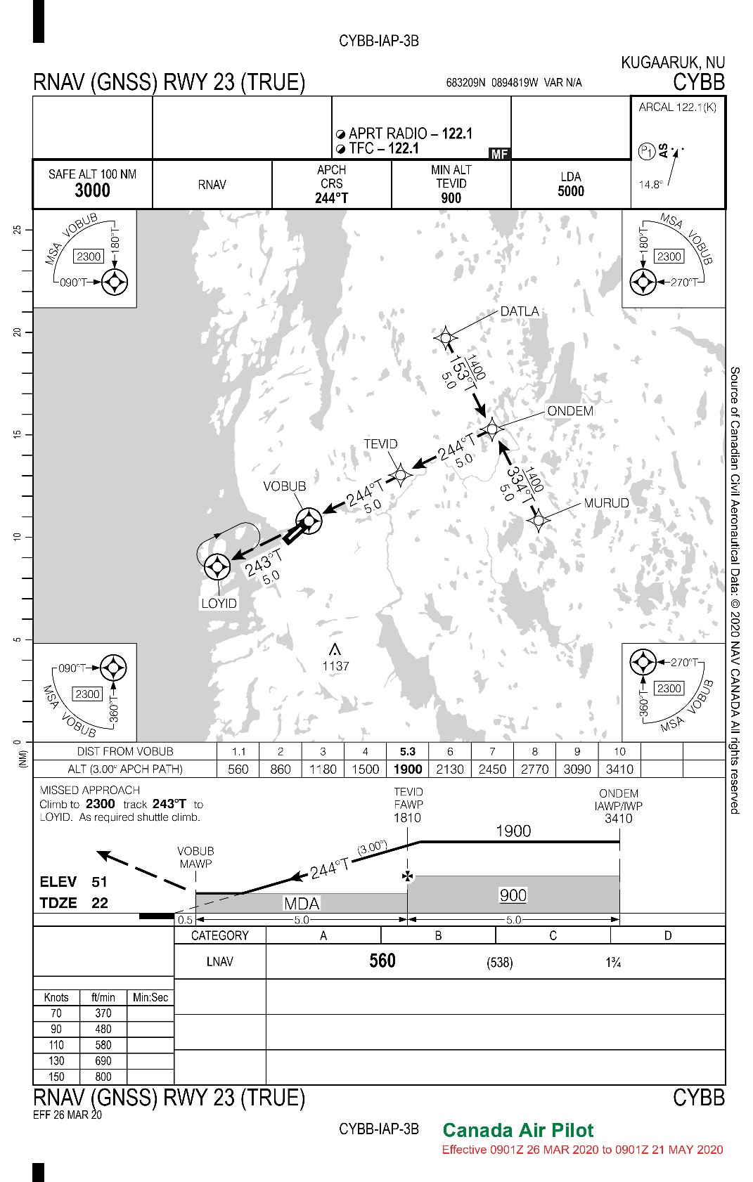
Source: Canada Air Pilot (CAP), CAP 1: Yukon, Northwest Territories and Nunavut (26 March 2020 to 21 May 2020).
Appendix B – Canada Air Pilot, General Pages, Aerodrome Operating Restrictions – Visibility
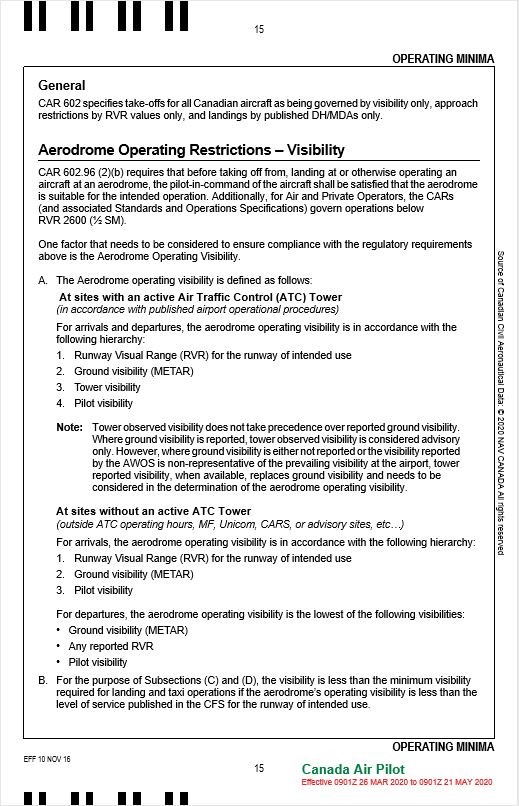
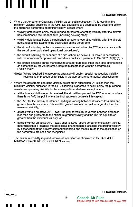
Source: Canada Air Pilot – Instrument Procedures – General Pages (CAP GEN) (26 March 2020 to 21 May 2020), pp. 15-16.